Six of the Statement’s figures are not reproduced online: Ordnance Survey and Historic England mapping, aerial imagery and a website screenshot. Their captions stay in place. Everything else, including the photographic record and the fabric studies, is shown as issued.
Document details, as issued
Statement of Heritage Significance
Project: Old Posingford Farmhouse, Chuck Hatch Road, Hartfield, East Sussex
Listing grade: Grade II
NHLE list entry: 1286584
Local planning authority: Wealden District Council
Generated: 28 September 2026
Prepared by
Assembled from: information and evidence confirmed by the home owner during site visits.
Prepared for: [client name withheld]
Heritage professional sign-off
This report has been generated by SOANE Architects Ltd. and RIBA registered Architects acting as qualified heritage professional.
Contents
1Introduction
1.1 Purpose and scope
- This Statement of Heritage Significance has been prepared for [client name withheld] in respect of Old Posingford Farmhouse, Chuck Hatch Road, Hartfield, East Sussex, a Grade II-listed building (NHLE list entry 1286584). It assesses the significance of the timber-clad garage and the single-storey brick storage barn, which fall within the curtilage of the listed farmhouse. It has been commissioned to accompany an application of a type (Listed Building Consent and/or full planning permission) remaining to be confirmed at submission stage, for the works described at §1.2.
- The assessment follows the National Planning Policy Framework (NPPF, August 2026) at Policy HE5(1) and Historic England Advice Note 12: Statements of Heritage Significance (HEAG279, October 2019), both of which require that assessment of a heritage asset's significance be proportionate to the asset's importance and to the impact of the proposal on that significance.
- This is not a complete or exhaustive history of the farmhouse. It is an assessment of significance proportionate to the scope of works at §1.2, based on documentary sources, map regression and fabric inspection as set out at §1.7.
- It is a statement of significance, not an advocacy document: it describes what matters about the asset and why, and does not extend into assessment of impact, design justification or the merits of the proposed works, which are addressed in the subsequent Heritage Impact Assessment.
1.2 Nature of the proposal
- The applicant proposes householder planning permission and Listed Building Consent for the refurbishment and environmental upgrade of the garage and storage barn, comprising: external fabric repair (rainwater goods, timber repairs, repointing, window and garage door replacement); roof works retaining the existing form, with a new ridge vent; new services (air source heat pump, rewiring, insulation to roof and walls, underfloor heating, electric vehicle charging point); retention and repair of the existing photovoltaic array; internal reconfiguration of partitions; and external landscaping and boundary treatment. No increase in footprint or extension is proposed. No change of use is proposed. Full details of the proposed works are set out in the accompanying application drawings and Design and Access Statement.
1.3 Designations
- Address: Old Posingford Farmhouse, Chuck Hatch Road, Hartfield, East Sussex
- List entry number: 1286584
- Grade: Grade II
- Date of listing: 31 December 1982
- Curtilage — professional determination , not yet confirmed:
- The storage barn and the garage are considered separately below, as the evidence for each differs.
- The storage barn retains internal fabric — including a stone/brick trough and associated pipework (Figs 28–29) — consistent with former dairy use, and the fabric elsewhere in the range is attributed on fabric evidence to a probable 18th- or early 19th-century agricultural origin (§2.1, §2.5). On this evidence, it is this Statement's professional opinion that the storage barn is likely to satisfy the tests set out in Attorney General ex rel Sutcliffe v Calderdale Borough Council (1983) — physical layout, ownership, and functional relationship to the farmhouse — but this has not been independently verified against documentary or map evidence predating 1897, and no legal determination has been made.
- The garage is a later structure. Map regression (Fig. 3) indicates it post-dates the 1908 Ordnance Survey edition. Whether it, or an earlier structure on the same footprint, existed before 1 July 1948 — the date that governs curtilage-listed status under section 1(5)(b) of the Planning (Listed Buildings and Conservation Areas) Act 1990 — has not been established from the evidence gathered for this Statement. Unless and until earlier documentary or cartographic evidence is obtained, the garage should not be treated as curtilage listed.
- This assessment is a professional opinion for the purposes of this Statement. It is not a legal determination.
- NHLE description (verbatim):
- HARTFIELD CHUCK HATCH 1. 5208 Old Posingford TQ 43 SE 12/102 II 2. C17. Two storeys. Three windows. Ground floor red brick and grey headers, above tile-hung. Tiled roof. Casement windows.
- Source: transcribed by the applicant from the official list entry, National Heritage List for England (historicengland.org.uk) — https://historicengland.org.uk/listing/the-list/list-entry/1286584?section=official-list-entry.
- See Fig. 1 for the NHLE statutory map extract.
Figure not reproduced in this online version: it contains Ordnance Survey mapping, which this site is not licensed to republish.
Fig. 1 — NHLE statutory map extract — list entry 1286584 — National Heritage List for England (historicengland.org.uk)
- Other designations:
Designation | Status |
|---|---|
Conservation Area | Not within a Conservation Area. |
National Landscape / AONB | The site lies within the High Weald National Landscape (Area of Outstanding Natural Beauty), as stated elsewhere in this Statement (§2.1, §2.4, §2.5). Precise boundary confirmation has been checked against MAGIC (Defra's designations map) and Wealden District Council. |
Site of Special Scientific Interest (SSSI) | Not within a Site of Special Scientific Interest |
Scheduled Ancient Monument (SAM) | No Scheduled Ancient Monument status. |
Tree Preservation Order (TPO) | No Tree Preservation Order recorded. |
1.4 Historic Environment Record (HER) reference
- Historic Environment Record (HER) status confirmed via Heritage Gateway.
- See Fig. 2 for the HER record evidence supplied by the applicant.
Figure not reproduced in this online version: it is a screenshot of a third-party website.
Fig. 2 — Historic Environment Record evidence supplied by the applicant — image.png
1.5 Archaeological potential
- Archaeological potential is assessed as low, on the basis that the proposed works are confined to the footprint of existing structures and their immediate curtilage, and the scope of ground disturbance is limited to shallow works associated with new services provision (air source heat pump installation, electric vehicle charging point cabling) and boundary treatment. This is not assessed as no potential: the site has been in continuous agricultural use since at least 1897 (§2.1), and below-ground remains associated with earlier phases of the farmstead cannot be excluded on the evidence gathered for this Statement.
1.6 Planning history
Reference | Date submitted | Date decided | Description of works | Decision | Relevance |
|---|---|---|---|---|---|
WD/1984/2452/F | — | 18 October 1984 | ERECT & CLAD A SWIMMING POOL ENCLOSURE OVER AN EXISTING SWIMMING POOL. | — | Relevance to the current proposal has not yet been assessed — to be completed by the heritage professional prior to submission. |
WD/1983/2456/F | — | 19 September 1983 | ERECTION OF CHANGING ROOM/GUEST ROOM | — | Relevance to the current proposal has not yet been assessed — to be completed by the heritage professional prior to submission. |
- Pre-application discussions
- The applicant has confirmed that no pre-application discussions have been held with the local planning authority in respect of the current proposal.
1.6b Setting and nearby listed buildings
- Nearby listed buildings and their contribution to setting are addressed in this section in accordance with Historic England GPA3 (Good Practice Advice in Planning 3).
Listed buildings nearby (setting context)
- The following listed buildings were identified within 2000m of the site (NHLE data):
Name | List entry | Grade | Distance | Date listed |
|---|---|---|---|---|
OLD POSINGFORD | 1286584 | II | 142m (<250m) | 31 December 1982 |
COTCHFORD FARMHOUSE | 1028301 | II | 335m (<500m) | 31 December 1982 |
FORESTLAND | 1028296 | II | 580m (<1km) | 26 November 1953 |
FROGSHOLE COTTAGE | 1262178 | II | 1086m (<2km) | 21 December 1994 |
Newtons Hill Cottage | 1433369 | II | 1137m (<2km) | 20 September 2016 |
NEWTONS TERRACE | 1028275 | II | 1146m (<2km) | 31 December 1982 |
ELDER COTTAGE | 1028303 | II | 1186m (<2km) | 31 December 1982 |
LAVENDER COTTAGE THE GALLYPOT INN | 1286545 | II | 1199m (<2km) | 31 December 1982 |
BALDWINS | 1192769 | II | 1242m (<2km) | 31 December 1982 |
Andbell House | 1286586 | II | 1266m (<2km) | 31 December 1982 |
SACKVILLE COTTAGE (INCLUDING THE FORMER BAKERY) | 1353555 | II | 1372m (<2km) | 31 December 1982 |
LARKSPUR | 1353569 | II | 1387m (<2km) | 31 December 1982 |
STAIRS FARMHOUSE | 1353556 | II | 1409m (<2km) | 31 December 1982 |
OLD BUCKHURST, THE MAIN HOUSE | 1353674 | II | 1415m (<2km) | 26 November 1953 |
- Contribution to setting: 14 designated heritage assets were identified within the 2000m search radius, 1 of which lies within 250m of the site. This concentration indicates that the site sits within a historic context in which nearby designated assets and the subject buildings are capable of contributing to one another's setting (GPA3).
- The specific contribution each nearby asset makes to the setting of the subject buildings — and any contribution the subject buildings make to theirs — is a matter of professional judgement informed by the setting and local character evidence at §2.4.
1.7 Approach and methodology
- This Statement identifies and articulates the significance of the asset using the three-part taxonomy of interests set out in Historic England Advice Note 12 (HEAG279, October 2019): archaeological interest, architectural and artistic interest, and historic interest (§2.2). Historic England's four-part heritage values framework, as set out in Conservation Principles, Policies and Guidance (English Heritage, 2008) — evidential, historical, aesthetic and communal value (paragraphs 35–55) — is drawn on as a supporting method within that primary framework, particularly in weighing the relative contribution of individual fabric elements (§2.7).
- Purpose of this Statement
- This Statement has been prepared to inform and accompany an application affecting a designated heritage asset. Sections 16(2), 66(1) and 72(1) of the Planning (Listed Buildings and Conservation Areas) Act 1990 require the decision-maker to have special regard to the desirability of preserving a listed building or its setting, and to the character or appearance of a conservation area, in exercising planning functions. The National Planning Policy Framework requires an applicant to describe the significance of any heritage assets affected, including any contribution made by their setting, in a level of detail proportionate to the assets' importance and no more than is sufficient to understand the potential impact of the proposal on that significance.
- This document sets out an understanding of the asset — its development, its fabric, and the interest it holds — sufficient for the significance of what may be affected to be understood before any judgement on the acceptability of works is made. It is a statement of significance; the impact of any specific proposal upon that significance is assessed separately (see §1.1).
- Method of assessing and apportioning significance
- Significance has been assessed by inspection of the asset and its setting and by review of the documentary, cartographic and photographic evidence set out in this Statement. In weighing the contribution of individual elements, regard has been had to their age and rarity; their intrinsic architectural and craftsmanship quality; their evidential value as a record of the building's development; their historical associations; their group value with the asset as a whole and its setting; and their typicality or exceptionality for their type, date and region.
- Where significance is apportioned between elements of the asset — in particular on the Building Age & Significance Plan (§2.7) — the following fixed six-marker scale is used, derived from the conservation-plan methodology established in Conservation Principles and standard sector practice:
- Blue — Exceptional significance
- Red — High/Considerable significance
- Yellow — Some significance (Medium)
- Green — Neutral significance
- Hatched — Negative/Detracting
- Cloud — Further investigation recommended
- The gradings recorded in this Statement are the professional judgement of the heritage professional responsible for it. Elements marked Cloud require further investigation before a settled grading can be assigned.
- Limitations of investigation
- The assessment supporting this Statement was based on a visual, non-intrusive inspection of the asset, together with a review of readily available documentary and cartographic sources. No opening-up of historic fabric, mortar or plaster analysis, paint research, dendrochronological dating, or below-ground archaeological investigation was undertaken for this Statement.
- Statements as to the date, phasing, authorship, or original form of fabric are accordingly matters of professional opinion formed on the visible evidence and the sources cited, unless a specific documentary source is identified in the text. Where the available evidence did not allow a claim to be independently verified, the judgement expressed is provisional and may be revised should further evidence — including any intrusive investigation subsequently commissioned — come to light. Concealed fabric may retain evidence, or defects, not identified by this assessment.
- This assessment draws on the following evidence gathered during preparation of this Statement:
- Documentary sources: historic map regression using the 1908 with current map overlay, 1908 and 1897 Ordnance Survey editions (§2.1); planning history search of Wealden District Council records (§1.6).
- Site inspection: site visits undertaken in February 2026 and July 2026; a close-up fabric feature study focusing on Windows, Special Features, Other, Ironmongery (§2.7); setting and local character photography (§2.4); general photographic survey (§2.5).
- Plans and drawings: site location and block plan (§2.2); survey drawings (§2.3).
2The heritage asset and its significance
2.1 Form and history — historic map evidence
- The garage and storage barn stand within the curtilage of the farmhouse (curtilage status considered separately at §1.3). The farmhouse itself is dated by its National Heritage List for England entry to the 17th century (§1.3). No map evidence earlier than 1897 has been obtained for this Statement, so the map sequence set out here — beginning with the OS Six-Inch map of 1897 (Sussex Sheet XVII.NW, Fig. 5) — considerably post-dates the farmhouse's documented origin and does not itself demonstrate anything about it.
- The 1897 map labels Posingford Farm as a small cluster of buildings west of the road now known as the B2026, with the Chalybeate Spring marked to the north-west. The present group of single-storey ancillary structures of differing dates, arranged around gravelled yards and a garden court, is recorded at §2.5; its position within the dispersed pattern of isolated farmsteads, ancient woodland and hedged pasture of the High Weald National Landscape is described at §2.4.
- The map sequence confirms that a farmstead recognisably similar in position and extent to the present group has stood on this site since at least 1897–1908; it does not establish the age of the ancillary buildings themselves, which is addressed on fabric evidence below.
- There is a tension between the fabric evidence and the map evidence in respect of the oldest apparent structure in the group. The low, single-storey brick outbuilding (Figs 15–17; §2.5) — hand-made red brick in Flemish bond, brick-lattice ventilation grilles, an arched-head gable window and a substantial external chimney stack — is attributed on fabric evidence to a likely 18th- or early 19th-century agricultural origin, whereas the earliest confirmed map depiction of the farmstead dates only from 1897. This is an evidential gap rather than a contradiction: the 1897 map records a smaller, less complex footprint than the present cluster, and the building could plausibly be among the structures depicted, but a firm construction date within or before the nineteenth century would rest on earlier cartographic sources such as tithe or estate mapping.
- The heavily patinated plain clay-tile roof and the internal roof structure of hand-worked coupled rafters, collars and principal posts (Fig. 26) are consistent with the earlier attribution but do not independently confirm it. Later interventions to this range — a boarded door and six-pane casement of probable mid-20th-century date, and a modern photovoltaic array to one roof slope (Figs 15, 16, 19) — record the building's continued adaptation.
- The black-stained weatherboarded ranges on low handmade-brick plinths with modern brick quoins are attributed on fabric evidence to the mid-to-late 19th or early 20th century (Figs 20, 22, 23, 25; §2.5). This fits the incremental growth the maps record: the 1908 OS Six-Inch map (Sussex XVII.1, Fig. 4) shows a cluster of farmhouse and outbuildings broadly matching the present arrangement, though additional structures in the current cluster are not clearly identifiable on the 1908 extract.
- The phasing of the weatherboarded ranges relative to the brick range cannot be resolved from the available map editions. Internal evidence of sustained agricultural use — the storage barn's exposed roof of irregularly profiled, surface-darkened timbers (Fig. 27), the former stable's common-rafter roof of probable 19th-century origin, its in-situ curved manger and the damp tide-mark indicating prolonged animal occupation (Fig. 30) — corroborates the working farmstead that the 1908 map's numbered agricultural parcels also record. The brick trough with corroded pipe stubs, likely of 20th-century origin, and the later timber shelf above it (Figs 28, 29), form a minor record of the building's past agricultural and domestic service arrangements.
- For the garage itself the map and photographic evidence converge. The overlay of the 1908 mapping against the current arrangement (Fig. 3) indicates that the existing garage post-dates 1908, and the survey drawings independently identify the timber-framed double garage as a later addition (Fig. 21; §2.5). Evidence of the original footprint still exists on site, confirmed by site inspection.. The precise construction date within the post-1908 period, and the fabric or materials of the later structures, cannot be determined from the map evidence alone. The open-fronted corrugated-iron lean-to (Fig. 25) and the brick-quoined outbuilding with a large timber garage door (Fig. 24) are likewise later, utilitarian additions; modern fencing panels, storage vessels, garden furniture and boulder vehicle-restraint markers are recent introductions (§2.5).
- The setting evidence (§2.4) and the nearby designations (§1.6b) bear on the curtilage relationship. The generous gravel apron and stone kerbing suggest incremental domestic adaptation of what was once a working farmyard (Fig. 11), though the date and sequence of that adaptation are not established photographically, and the map extracts do not resolve it. The juxtaposition of weatherboarded outbuildings against the tile-hung and brick farmhouse, the mixed clay-tile and slate roofscape, and the mature hedgerow boundaries preserve open yard relationships characteristic of historic Wealden farmstead layouts, while the persistence of the spring to the north-west across all map editions ties the present-day site to its nineteenth-century depiction. Cotchford Farmhouse (Grade II, list entry 1028301), the nearest separately listed building at approximately 335m, illustrates the same local pattern of farmhouses set within established garden and tree-canopy settings (Fig. 14; §2.4), though the date of the available photograph and any subsequent alterations there are not established. The historic evolution of the wider field pattern and site boundaries before 1897, suggested by the pond and exposed sandy ground visible in aerial photography (Fig. 10), would depend on cartographic evidence not presently available ..
- Fig. 3 caption — The red-outlined building is the original building form prior to the current garage and storage barn configuration
Figure not reproduced in this online version: the modern overlay contains current mapping this site is not licensed to republish.
Fig. 3 — Historic map — 1908 with current map overlay — Old Maps Online — The 1908 extract with the current building footprints overlaid. Footprints and general arrangement correspond broadly with the present-day layout. .
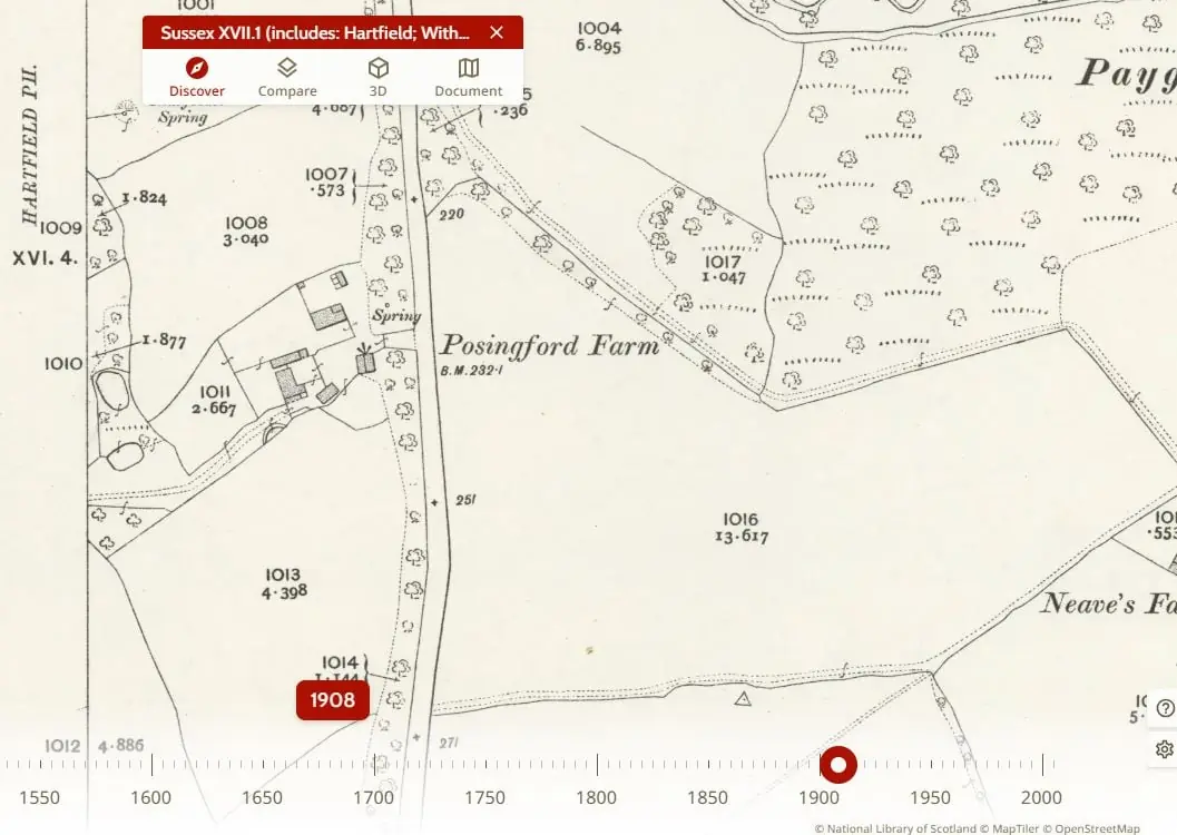
Fig. 4 — Historic map — 1908 — OS Six-inch to the mile, Sussex XVII.1 (includes Hartfield; With...), surveyed/published 1908, via National Library of Scotland — The extract labels 'Posingford Farm' with a benchmark of B.M. 232·1. A cluster of building footprints, apparently a farmhouse with associated outbuildings, stands west of the road (Cotchford Hill); a spring is marked immediately to the north-west, and the surrounding parcels are numbered with acreage figures.
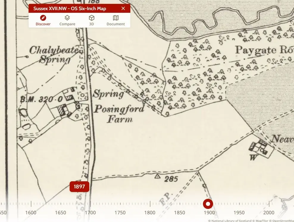
Fig. 5 — Historic map — 1897 — OS Six-Inch Map, Sussex Sheet XVII.NW, 1897, National Library of Scotland — The extract labels Posingford Farm, with a small cluster of buildings west of the north–south road (now the B2026, Cotchford Hill). The Chalybeate Spring is marked to the north-west.
Figure not reproduced in this online version: it contains Ordnance Survey mapping, which this site is not licensed to republish.
Fig. 6 — Current-day comparison view — The pinned site at TN7 4HA shows a loose cluster of building footprints around a shared yard or access area, immediately west of the B2026 (Cotchford Hill). Several rectangular structures of varying size form the main group, with smaller outbuildings to the south and south-west. A drain runs along the eastern edge parallel to the road, with further drains and low-lying ground to the west and scattered ponds in the wider landscape. A separate building cluster lies to the north, also fronting Cotchford Hill, and another to the south-east across the road junction.
2.2 Site location and block plan
Figure not reproduced in this online version: it contains Ordnance Survey mapping, which this site is not licensed to republish.
Fig. 7 — OPF-PL-Ex-001 - Site and Location Plans.pdf
- The site location and block plan submitted with this application (Fig. 7) are reproduced at the largest size the page allows so that boundaries, scale and north point remain legible.
2.3 Survey drawings
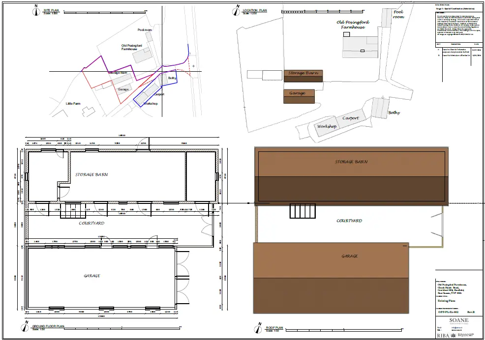
Fig. 8 — OPF-PL-Ex-003 RevA - Existing Plans.pdf — The drawing generally demonstrates good legibility, with clear text for labels, dimensions, and notes, making it suitable for reproduction and printing. Materiality is not explicitly labelled, though different areas are shaded on the roof plan, possibly indicating varying materials or simply distinguishing elements. Extensive dimensional information is provided on the ground floor plan. The site and location plans effectively establish the building's relationship to its immediate context, showing adjacent structures like 'Pool Room' and 'Little Farm'.
First-pass quality check — not a guarantee of planning authority validation: North point: Present; Scale bar: Present; Title block (reference, revision, date, client, site address): Present; Disclaimer / notes block: Present; Drawing reference number and revision: Present.

Fig. 9 — OPF-PL-Ex-003 RevA - Existing Elevations.pdf — The drawing demonstrates good legibility with clear text and labels for various elements and materials. Text sizes are generally appropriate for reproduction and printing, though some disclaimer text is small. Materiality is well-labelled across all elevations, detailing specific finishes and components. While no explicit dimensions are provided on the elevations, numerical scales are clearly indicated for all views. A location plan and adjacent features on elevations effectively communicate the relationship of the buildings to their setting and immediate context.
First-pass quality check — not a guarantee of planning authority validation: North point: Present; Scale bar: Present; Title block (reference, revision, date, client, site address): Present; Disclaimer / notes block: Present; Drawing reference number and revision: Present.
- The existing-condition survey drawings for the application buildings are reproduced at Figs. 8 and 9.
2.4 Setting and local character photographs
- This section presents 5 photographs, covering other setting evidence, street views, and historic photographs of the setting.
- This section considers the photographic and illustrative evidence for the setting and local character of the garage and storage barn within the High Weald National Landscape: aerial, street-level, historic and illustrative viewpoints recording the farmstead group, its immediate curtilage and comparable buildings in the wider locality.
- The aerial view (Fig. 10) establishes the character of the setting. The farmhouse sits within a deeply rural, well-wooded landscape accessed via a long private lane off Chuck Hatch Road, forming part of a dispersed settlement pattern of isolated farmsteads and large residential plots separated by ancient woodland, hedgerows and open pasture — a landscape form typical of the Wealden small farm tradition. A nearby pond and areas of exposed sandy ground suggest former agricultural or extractive land use in the immediate hinterland. The street-level view from the gravel forecourt (Fig. 11) repeats this pattern at the scale of the farmstead itself: an informal group in which a weatherboarded outbuilding and barn structure stand in contrast to the tile-hung and brick cottage, with mixed clay pantile and plain tile roofscapes, timber fencing and mature deciduous trees sustaining the small-scale agricultural character of this part of East Sussex.
- The High Weald vernacular building tradition recurs across the viewpoints. Figs 12 and 13 are illustrative material — an artist's render of the farmhouse and a watercolour of a neighbouring bothy, both supplied by the client — rather than survey photographs, and their accuracy against the buildings as existing has not been confirmed. They are included here as an indication of local character only; no conclusion about the farmhouse's or the bothy's actual current condition, fabric or degree of alteration is drawn from either. Current-condition survey photography of the farmhouse itself has not been obtained for this Statement and should be sought before submission. Allowing for their illustrative status, the depictions are consistent with a local palette of tile, brick, stone, timber and informal boundary treatments also seen in the confirmed photographic evidence at §2.5.
- The historic photograph of Cotchford Farm (Fig. 14), the nearest other listed building in the area (see §1.6b), extends this picture into the wider setting and its time-depth. Its buff/yellow stock brick rear elevation, clay-tiled roof, tall chimney stacks and multi-pane timber casements are attributed an Arts and Crafts or inter-war domestic character, while the swimming pool and associated paving are later twentieth-century additions to that curtilage. This view records the historic relationship between a farmhouse and its garden setting in this locality, and demonstrates a pattern — echoed at Old Posingford by the generous gravel apron and stone kerbing in the forecourt view (Fig. 11) — of incremental domestic adaptation of formerly working agricultural curtilages within an established, mature landscape framework, bearing on the relationship between the curtilage and the listed farmhouse.
Figure not reproduced in this online version: it is third-party aerial imagery.
Fig. 10 — Aerial view: Old Posingford Farm setting — Aerial View showing Old Posingford Farmhouse in context — The farmhouse (red arrow) within well-wooded country, reached by a long private lane off Chuck Hatch Road; ancient woodland, hedgerows and open pasture separate isolated farmsteads and large residential plots. A pond and areas of exposed sandy ground lie nearby.
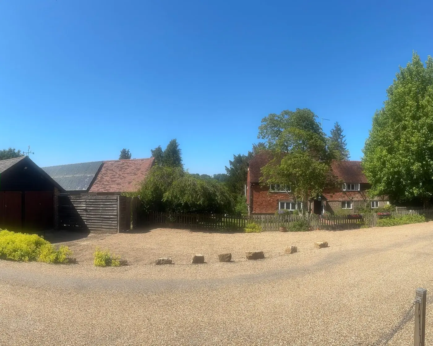
Fig. 11 — Farmstead setting: barn and cottage, Chuck Hatch R — Street view — View from the gravel forecourt: weatherboarded outbuilding and barn structure to the left, tile-hung and brick cottage to the right, under mixed clay pantile and plain tile roofs, with timber fencing and mature deciduous trees. Gravel apron with stone kerbing in the foreground.
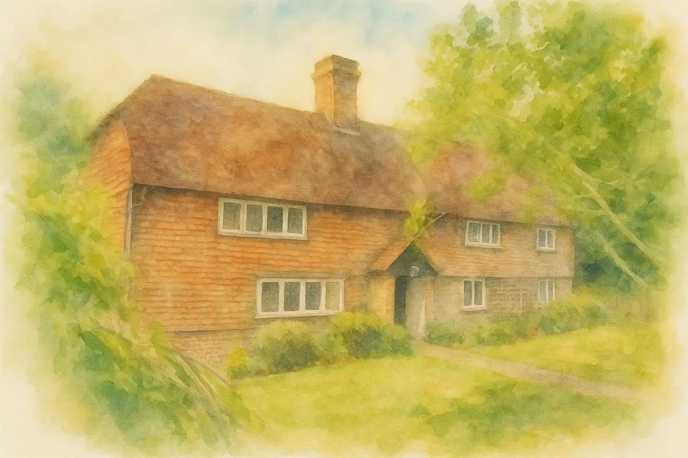
Fig. 12 — Tiled farmhouse in wooded rural setting — Main House as artist's render from client — Artist's render, not a survey photograph. Two-storey farmhouse with steeply pitched tiled roof, brick chimney stack and tile-hung and brick elevations; white-painted casement windows at ground and first floor; mature informal garden framed by substantial deciduous trees.
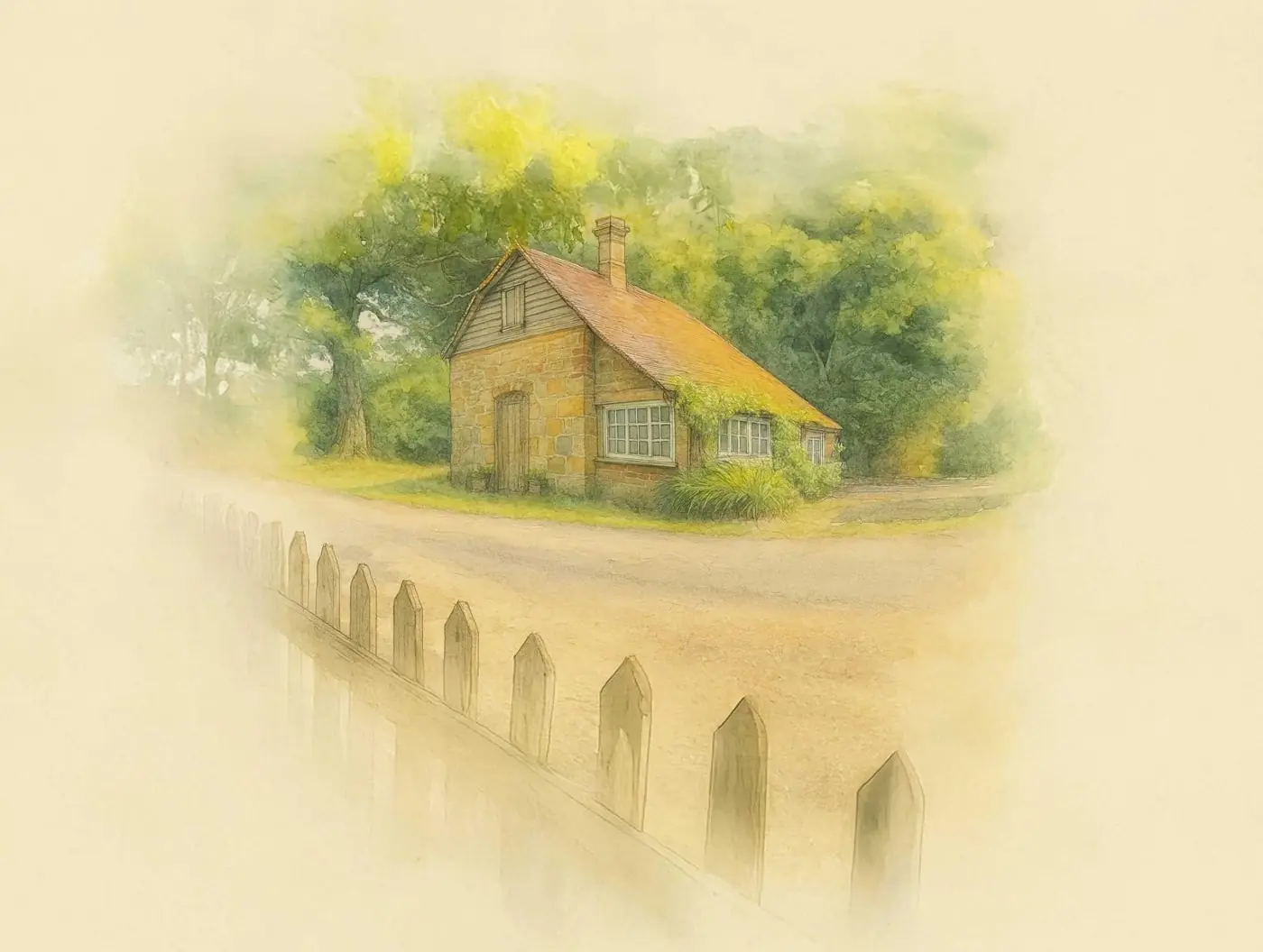
Fig. 13 — Stone cottage & picket fence, rural lane — Neighbouring Bothy Building — Watercolour illustration, not a photograph. Small stone cottage with orange-red pitched roof, chimney stack and casement windows partly draped in climbing plants; picket fence in the foreground; mature deciduous trees and open grassy ground behind.
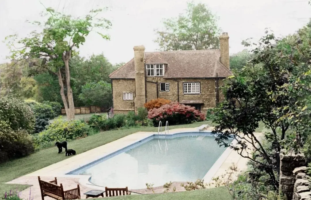
Fig. 14 — Cotchford Farm Rear garden & pool — Historic photo — Colourised historic photograph of the rear elevation of Cotchford Farm, taken from an elevated garden vantage point with a rectangular outdoor swimming pool and associated paving in the foreground. Buff/yellow stock brick facade, clay-tiled roof, tall chimney stacks and multi-pane timber casement windows, set within a mature tree canopy and informally planted garden.
- The setting evidence — principally the aerial and street-level photographs at Figs. 10 and 11, supported by the illustrative material at Figs. 12 and 13 — demonstrates that the garage and storage barn stand within a legible High Weald farmstead group of dispersed, vernacular character. Its wooded rural landscape, informal farmyard curtilage and relationship to the listed farmhouse are the principal contributors to the setting component of significance.
2.5 General photographic record
- This section presents 17 photographs, covering the south elevation, the west elevation, the garden and boundary areas, the north elevation, the east elevation, the curtilage outbuildings, the ground floor, and the first floor.
- This section presents the general photographic record for the garage and storage barn at the farmhouse: the exterior elevations of the outbuilding group, the surrounding yard and garden spaces, and internal views of roof structures and surviving agricultural fitments within the curtilage of the Grade II listed farmhouse.
- The photographs record a consistent vernacular material palette across the outbuilding group, characteristic of High Weald farmstead building traditions: hand-made red brick, in one instance laid in Flemish bond (Fig. 15); plain clay tiles and peg-tiles with varied patination and lichen growth indicating age; and black-stained or darkened horizontal weatherboarding on low brick plinths, in places with brick quoins or return corners suggesting composite masonry-and-timber construction. Traditional detailing recurs across several structures: brick-lattice ventilation grilles, small multi-pane timber casement windows, boarded doors with strap hinges, and an arched-head window with multi-pane glazing to one gable (Fig. 17), which appears to be original or early. All point to functional agricultural or ancillary domestic use.
- The photographs indicate an incrementally developed farmstead of several phases. The brick outbuildings are of likely 18th- or early 19th-century origin (Figs. 15–16; Fig. 17 reads more broadly as 18th- or 19th-century), with tonal variation in the brickwork read as evidence of age and possibly of phased construction or repair. A ventilation slot or former loading opening in the south elevation (Fig. 16) suggests a former agricultural function such as a cart shed or stable. The weatherboarded ranges are attributed to the mid-to-late 19th or early 20th century. Clearly later elements include a modern timber-framed double garage identified on the survey drawings as a later addition, an adjacent open-fronted corrugated-iron lean-to, mid-20th-century door and window insertions (Fig. 15), and a substantial photovoltaic array on one rear roof slope. The precise sequence and dating of these phases exceeds what the photographs alone can confirm. An external chimney stack at one gable end (Fig. 15) indicates a former functional hearth, pointing to a domestic service use such as a farm worker's store or dairy.
- The brick range retains considerable evidential and historic value as part of the working farmstead group and contributes to the agricultural character of the curtilage and to the vernacular agricultural character of the High Weald National Landscape; its grading is recorded at §2.7, on the dating basis set out at §2.8, which is the settled position where it differs from the fabric-based reading above..
- Internally, the record captures exposed roof carpentry across several spaces: coupled rafters with collar ties and principal posts in the barn (Fig. 26), principal rafters with purlins and close-spaced common rafters over boarding (Fig. 27), and exposed softwood ceiling joists at a wall-head junction (Fig. 31). The hand-worked, patinated timbers are read as likely original or early fabric, with limited later intervention at roof level. Surviving fitments add to the evidential record of the buildings' working use: an in-situ manger in the former stable, with a soiling tide-mark consistent with prolonged animal occupation (Fig. 30), and a 20th-century rendered brick trough with corroded pipe stubs relating to a former water supply or drainage arrangement (Figs. 28–29), the trough being later fabric of low evidential value.
- Across the yard and garden views, the photographs record the spatial relationships that bind the group together: a gravelled farmyard court (Fig. 24) and a narrow service courtyard (Fig. 18) flanked by outbuilding ranges of differing character and date, an open yard relationship between structures preserved despite present-day domestic use of the garden curtilage (Fig. 16), and a mature hedgerow boundary contributing to the rural setting (Fig. 24). Modern additions — hardstanding, fencing panels, storage vessels, boulder vehicle-restraint markers and the solar inverter (Figs. 18, 24 and 30) — do not contribute to, or do not obscure, the historic fabric.
- Photograph Location Plan
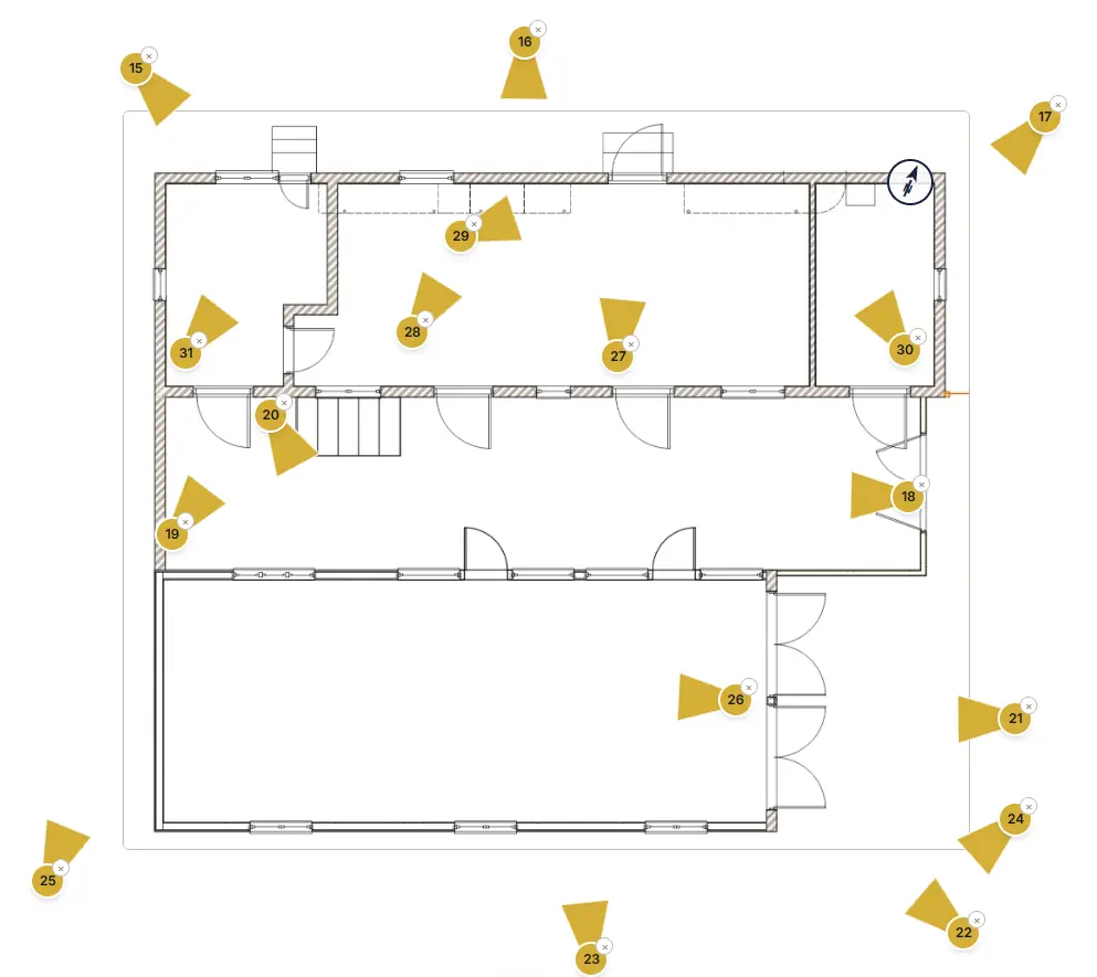 - This plan shows the ground floor layout of the garage and storage barn. The numbered markers show where each photograph in this section was taken and the direction the camera was pointing, with north marked at the top of the plan. The photographs that follow are presented in that same numbered sequence, starting with Fig. 15 below.
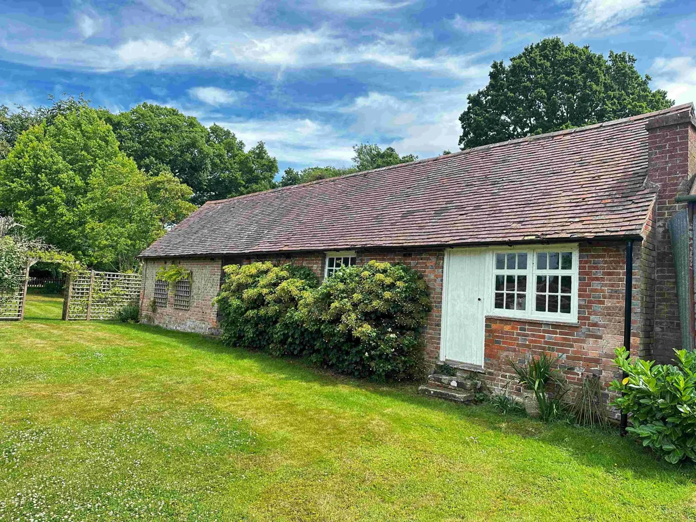
Fig. 15 — Brick outbuilding south elevation & garden — Exterior - South — General View / Elevation — Long, low single-storey outbuilding in hand-made red brick laid in Flemish bond, under a plain clay tile roof with varied patination and lichen growth. Modest ventilation apertures with brick-lattice grilles; a later boarded door and small six-pane painted timber casement. Substantial external chimney stack at the right-hand gable end.
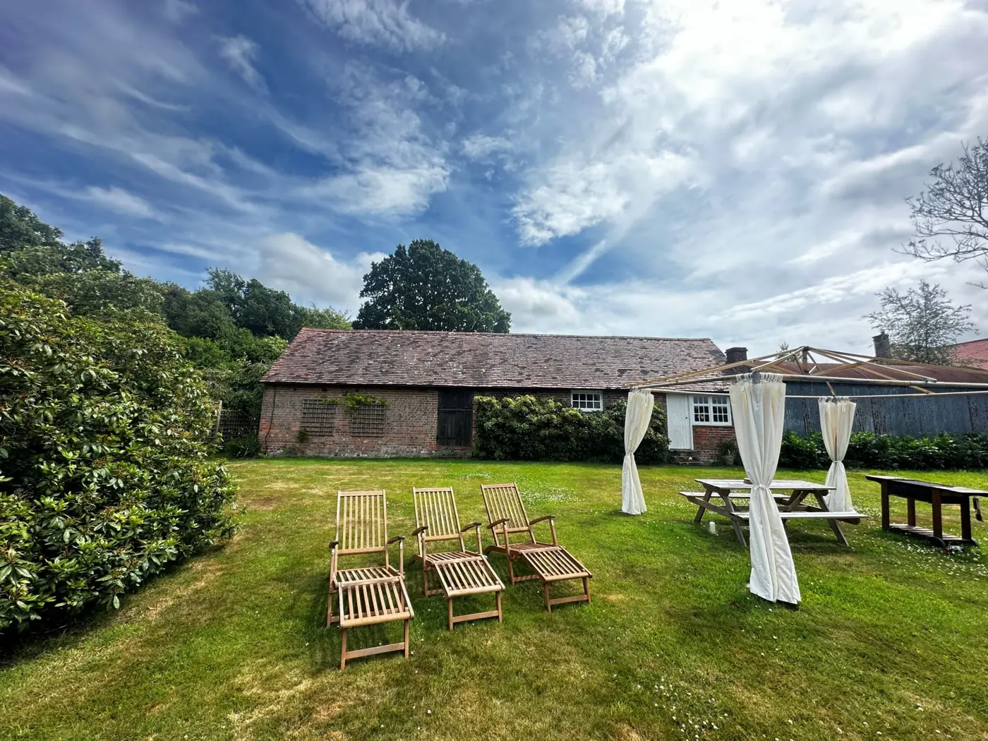
Fig. 16 — Outbuilding S elevation & garden court — Exterior - South — General View / Elevation — South-facing elevation of the low, single-storey red brick outbuilding beneath a plain clay tile roof of pronounced low pitch. Weathered brickwork with tonal variation; a ventilation slot or former loading opening left of centre. Foreground laid to lawn with contemporary leisure furniture.
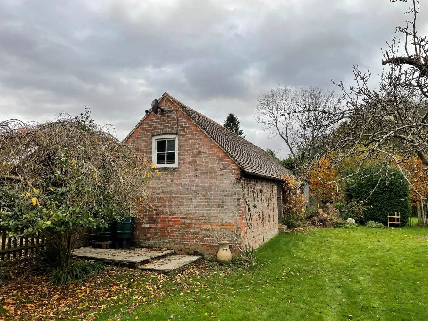
Fig. 17 — Gable end & roof: brick outbuilding — Exterior - West — General View / Elevation — Small, steeply pitched outbuilding of hand-made red brick under a plain clay tile roof. The gable retains an arched-head window with a simple timber frame and multi-pane glazing. The brickwork shows considerable variety in colour and texture.
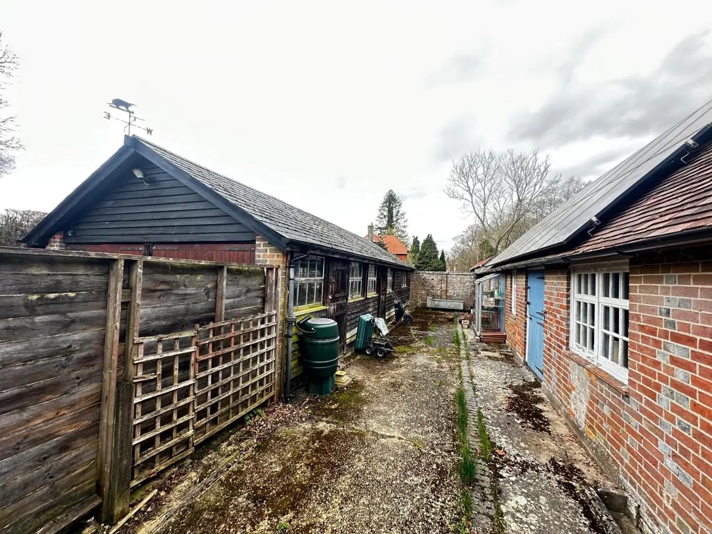
Fig. 18 — Rear courtyard: outbuildings and yard — Garden / Boundary — General View / Elevation — View along the narrow service courtyard. Left: a weatherboarded structure with slate roof and badger weather vane above a lower lean-to range with small-paned glazed lights, the darkened boarding suggesting a 19th-century agricultural or stable origin. Right: a red brick range with white-painted casements under a pantile roof, apparently later, possibly early-to-mid 20th century, and of lower evidential significance. Hardstanding, fencing panels and plastic storage vessels in the foreground.
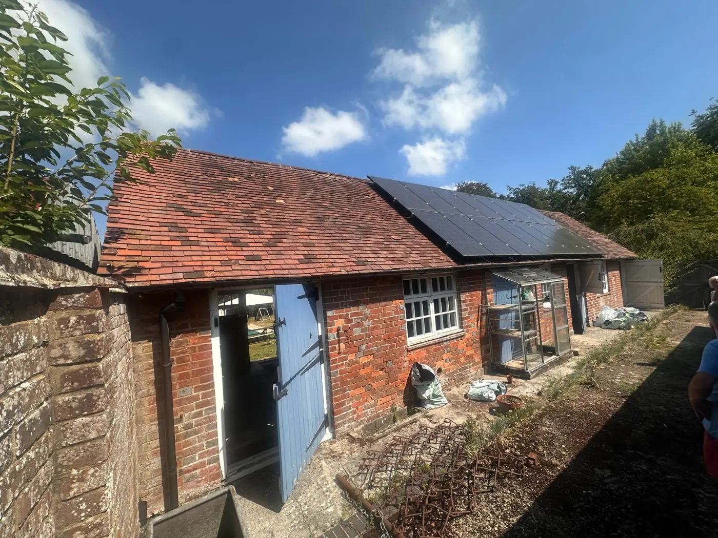
Fig. 19 — Outbuilding south elevation: brick, tiles, PV — Exterior - North — General View / Elevation — Single-storey red brick outbuilding, likely of 19th-century agricultural origin, under a weathered plain clay tile roof. Boarded stable door painted pale blue, retaining what appear to be original strap hinges, suggesting survival of early functional ironmongery. Small multi-pane timber casement to the right of the door, of Victorian or Edwardian type. A photovoltaic array covers most of the rear roof slope; the roof covering is otherwise largely intact.
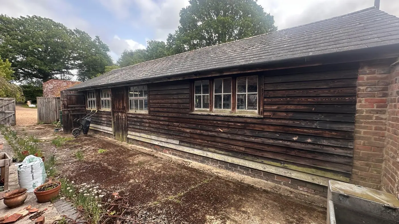
Fig. 20 — Weatherboarded outbuilding south elevation — Exterior - South — Wall Fabric (brick, stone, timber-frame) — Long south elevation of horizontal feather-edged weatherboarding, heavily darkened with age and residual preservative treatment, on a low brick plinth with a plain projecting sill course; a return corner in red brick with cement mortar pointing at the right-hand end. Regularly spaced small-pane glazed windows with painted timber frames are set directly into the boarding, likely reflecting use as a workshop, stable or store. Minor repair boarding at low level.
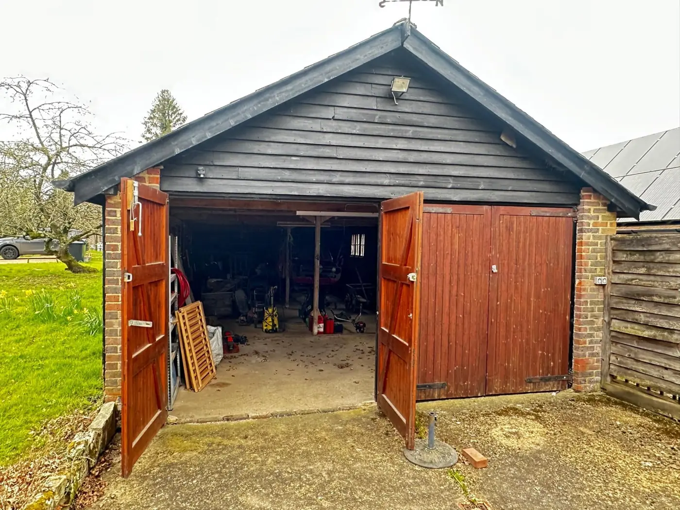
Fig. 21 — Double garage: south elevation & doors — Exterior - West — General View / Elevation — The timber-framed double garage (later addition; see §2.7, Neutral), finished in dark-stained horizontal weatherboarding above brick quoin corners, under a pitched roof with a decorative weathervane at the apex. Paired boarded doors stained red-brown with strap hinges, of functional rather than historic character. Its recent date and non-traditional materials distinguish it from the principal historic fabric.
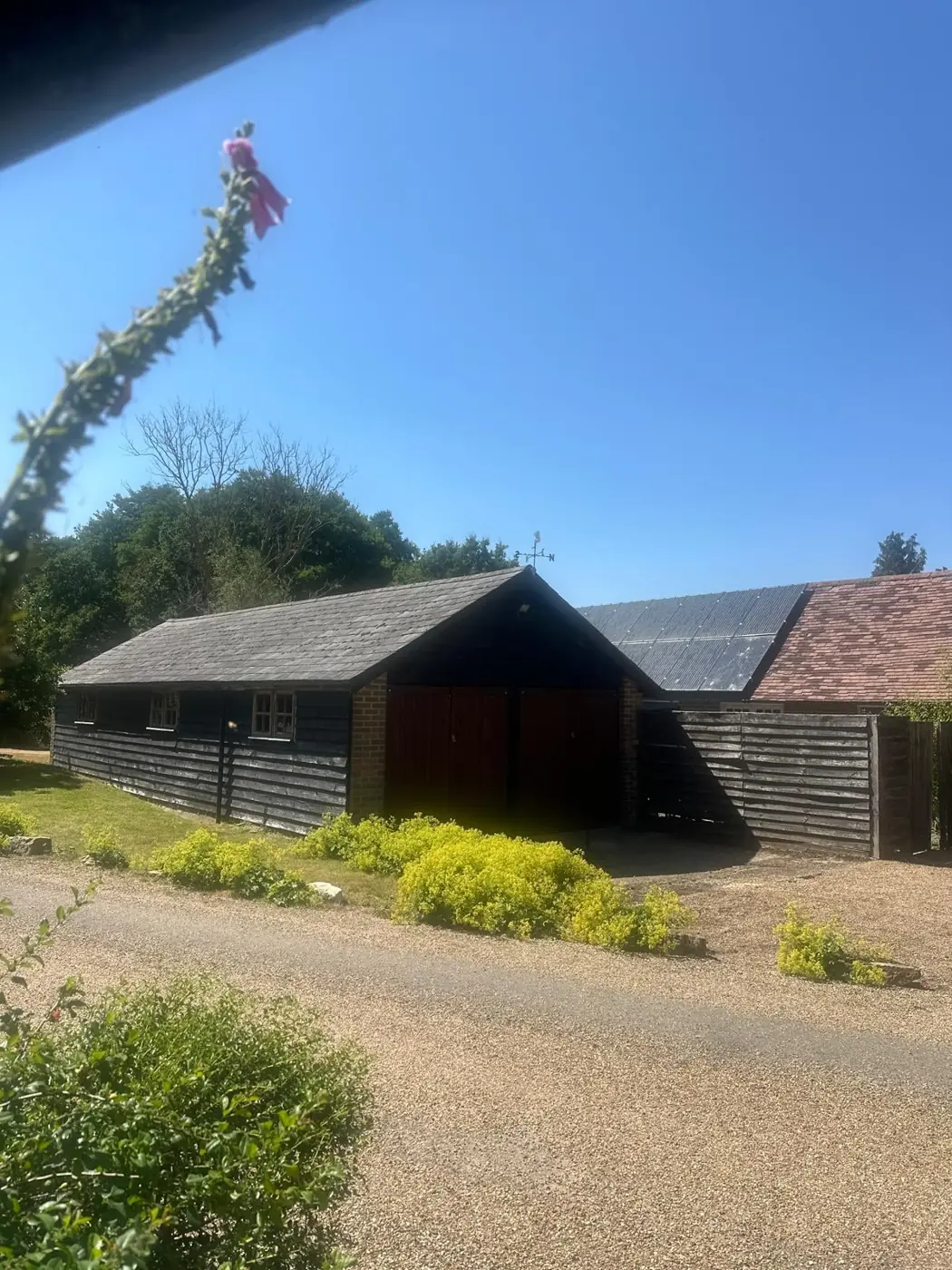
Fig. 22 — Timber-clad outbuilding, front elevation — Garden / Boundary — General View / Elevation — Single-storey outbuilding clad in horizontal black-painted weatherboarding. The gabled frontage has a pair of red-painted boarded double doors within a brick surround, with small multi-pane windows to the flank elevation and a slate-effect roof covering; form suggests a cart lodge or stable. Reasonable material integrity despite probable later modifications. Weather vane at the ridge.
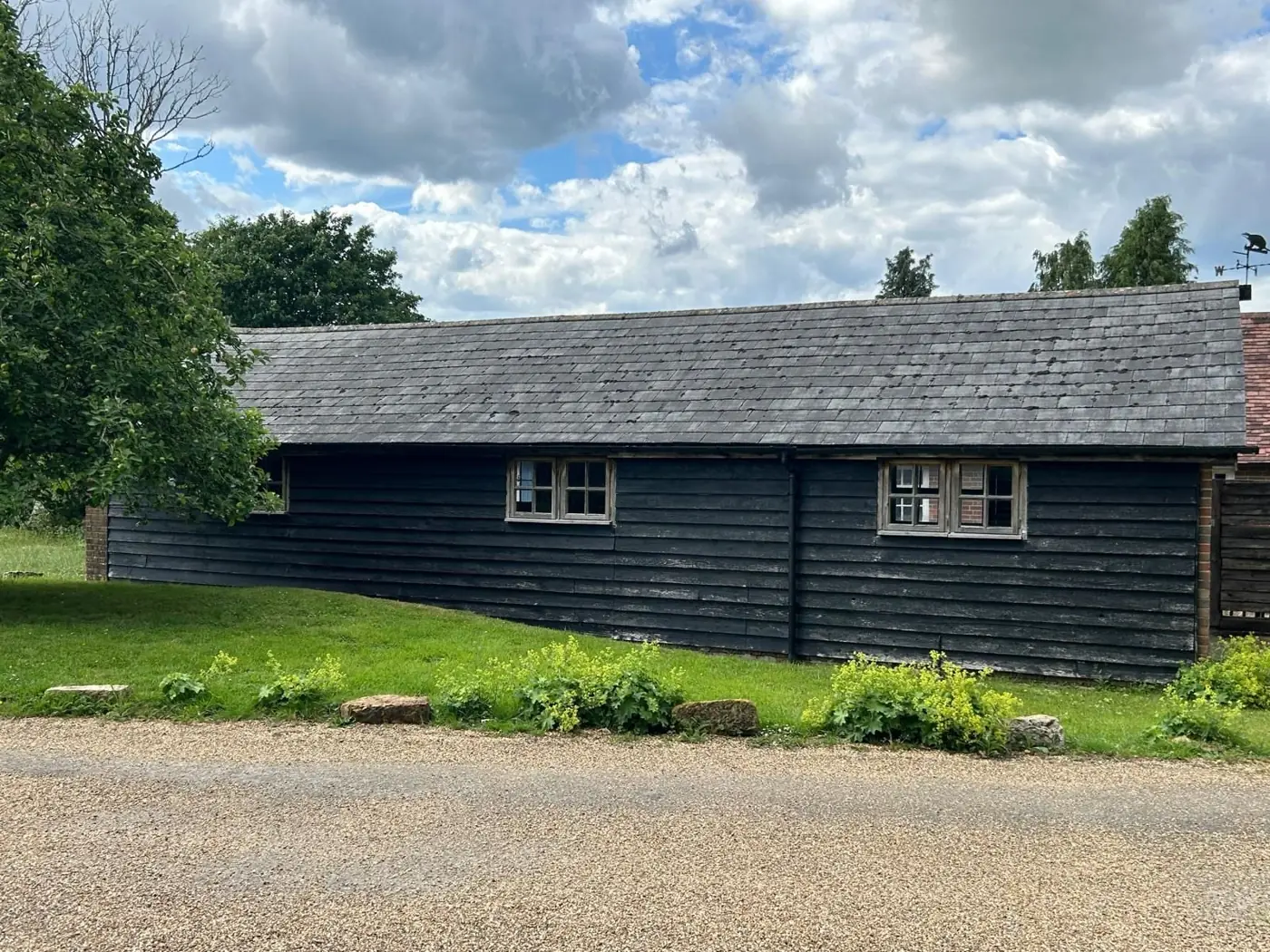
Fig. 23 — Black-stained weatherboard outbuilding, S elevation — Exterior - North — General View / Elevation — Long, low south-facing elevation clad in horizontal black-stained weatherboarding under a plain slate roof at a shallow pitch, with brick quoins at the corners. Two small multi-pane timber casements with unpainted timber surrounds; their modest scale and plain detailing are consistent with functional agricultural use rather than domestic conversion.
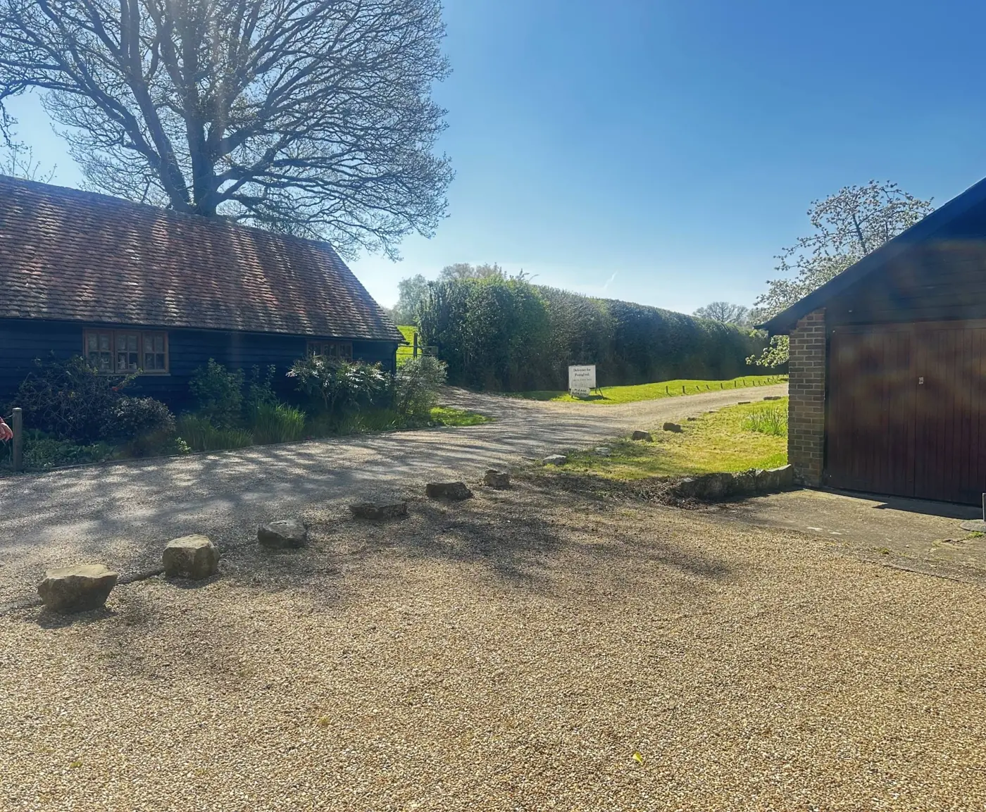
Fig. 24 — Farmyard court: barn & outbuildings looking N — Garden / Boundary — General View / Elevation — View north across the gravelled farmyard court. Left: single-storey timber-framed structure clad in dark-stained weatherboarding under a plain clay tile roof, likely former farm ancillary accommodation. Right: brick-quoined outbuilding with a large timber garage door, apparently a later 20th-century addition. Irregularly placed sarsen or sandstone boulders serve as informal vehicle-restraint markers; mature hedgerow boundary to the north.
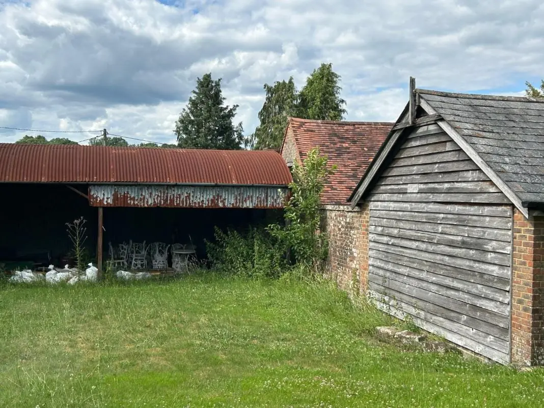
Fig. 25 — Farmyard outbuildings: barn & open shelter — Exterior - East — Wall Fabric (brick, stone, timber-frame) — Timber-framed gable end clad in weathered horizontal weatherboarding on a low plinth of handmade brick. The pitched roof retains what appear to be plain clay peg-tiles, patinated with lichen, suggesting original or early fabric of local character. To the left, an open-fronted lean-to shelter under a corrugated iron roof: a later, utilitarian addition of considerably lower significance.
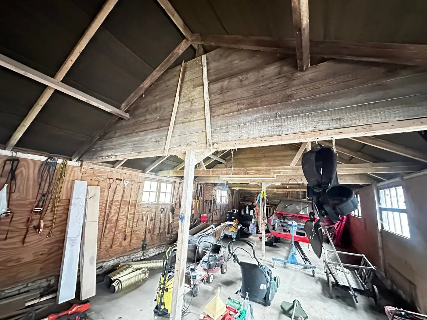
Fig. 26 — Barn interior: roof trusses & working use — Curtilage / Outbuilding — Roof Structure (trusses, purlins) — Interior of the timber-framed barn, showing an exposed roof of coupled rafters with collar ties and principal posts, likely of -20th to 21st-century origin, with boarding to the underside of the rafters and weathered, unfinished timber throughout. Plywood sheet lining to the lower wall framing is a later, non-original alteration.
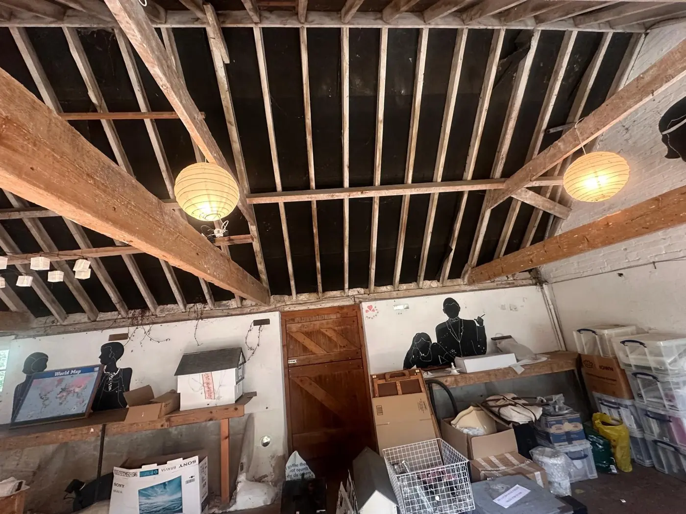
Fig. 27 — Exposed roof structure & boarded soffit — Ground Floor — Roof Structure (trusses, purlins) — Exposed roof of principal rafters, purlins and close-spaced common rafters, with the underside of the roof boarding visible between them. The timbers are hand-worked, with irregular profiles and surface darkening, possibly of 18th- or 19th-century date. A low wall plate at eaves level rests on rendered masonry walls with traces of limewash. The space is in storage use, with later decorative interventions to the walls.
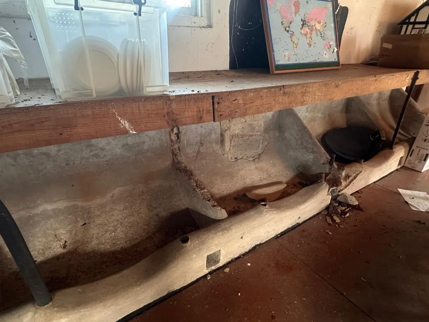
Fig. 28 — Brick trough in situ below timber shelf — Ground Floor — Services (historic - not modern M&E) — Rendered brick-built sink or trough surviving in situ, with a broad shallow basin and a moulded front lip. The timber shelf fixed above it is of later date than the trough and probably associated with domestic or dairy use of the storage barn. The cement render is worn, with limited areas of spalling.
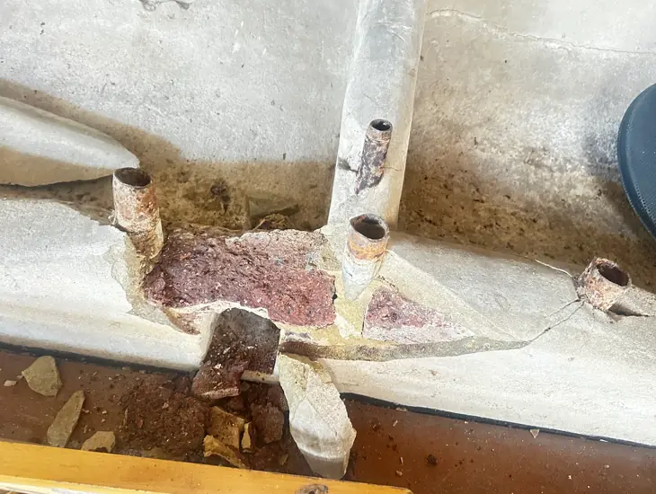
Fig. 29 — Corroded pipe stubs in trough — Ground Floor — Modern trough detail with cement — Close-up of the trough, showing cementitious mortar and render around the brickwork and several corroded mild-steel or iron pipe stubs set within it. Rust staining and mortar spalling around the stubs indicate long-term moisture exposure and repair of the fitment over time.
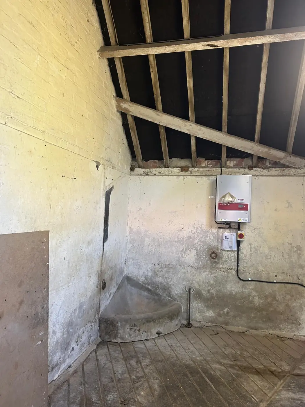
Fig. 30 — Stable interior: manger, roof structure — Curtilage / Outbuilding — Roof Structure (trusses, purlins) — Interior of the former stable, retaining an exposed common-rafter roof of unpainted softwood or mixed timber, probably of 19th-century origin. A curved stone or cast-concrete manger/trough, an original agricultural fitment, survives in situ at the base of the rear wall. The later rendered brick walls show a distinct damp tide-mark, with the lower portion more heavily soiled. A modern Fronius solar inverter is surface-mounted to the rear wall.
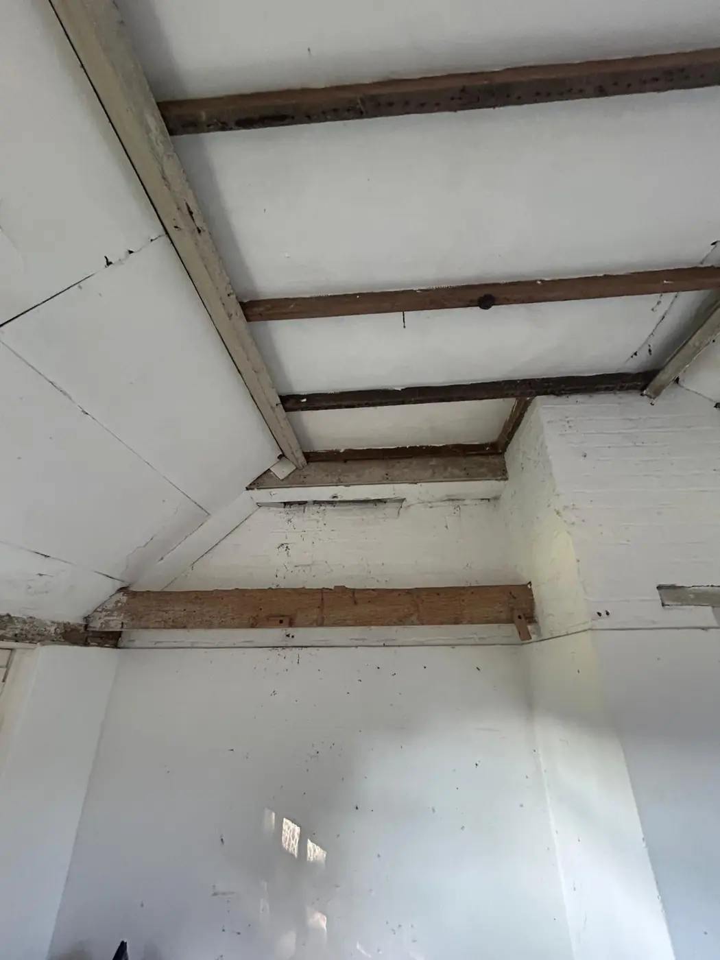
Fig. 31 — Exposed ceiling joists at wall-head junction — upper level— Roof Structure (trusses, purlins) — Exposed softwood ceiling joists across a upper level, with the boards between them painted white. At the wall-head, a horizontal wall plate, likely of sawn softwood, connects the joist ends to the masonry or timber-framed wall beneath. The joists show surface patination and minor soiling.
- The photographic evidence demonstrates a legible, multi-phase farmstead group retaining a coherent vernacular material palette, substantially intact roof carpentry and surviving agricultural fitments. Its evidential and historic interest lies principally in illustrating traditional High Weald farm building practice associated with the Grade II listed farmhouse, within a curtilage relationship considered at §1.3. Overall significance is assessed at §2.8.
2.6 Fabric feature studies
Windows — detailed study
- The windows studied span, on current evidence, from a genuine late Georgian original to twentieth-century replacements and pastiche copies. Fig. 39 is the earliest and most significant of the group — a three-over-six top-hung casement with slender glazing bars and a clay-tile-on-edge sill, consistent with late eighteenth- or early nineteenth-century joinery. Fig. 38, though similar in general form, is a later, poorly matched approximation of this type, with heavier glazing bars and simpler detailing. Fig. 40 is a cobbled-together window combining mismatched elements and glass of differing ages, and is of low evidential value. The remaining outbuilding casements are more varied in date and of lesser individual significance, but together illustrate the complex's successive phases of agricultural and ancillary use.
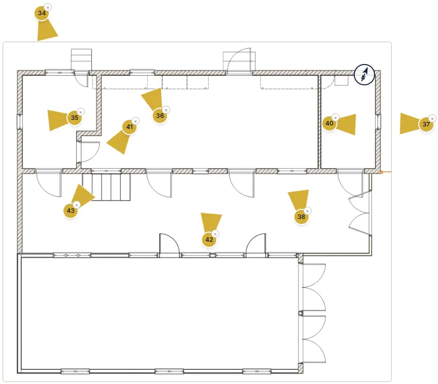
This plan shows where each close-up photograph in this study was taken and the direction the camera was pointing, with north marked at the top. The photographs that follow are presented in that same sequence, starting with Fig. 34 below.
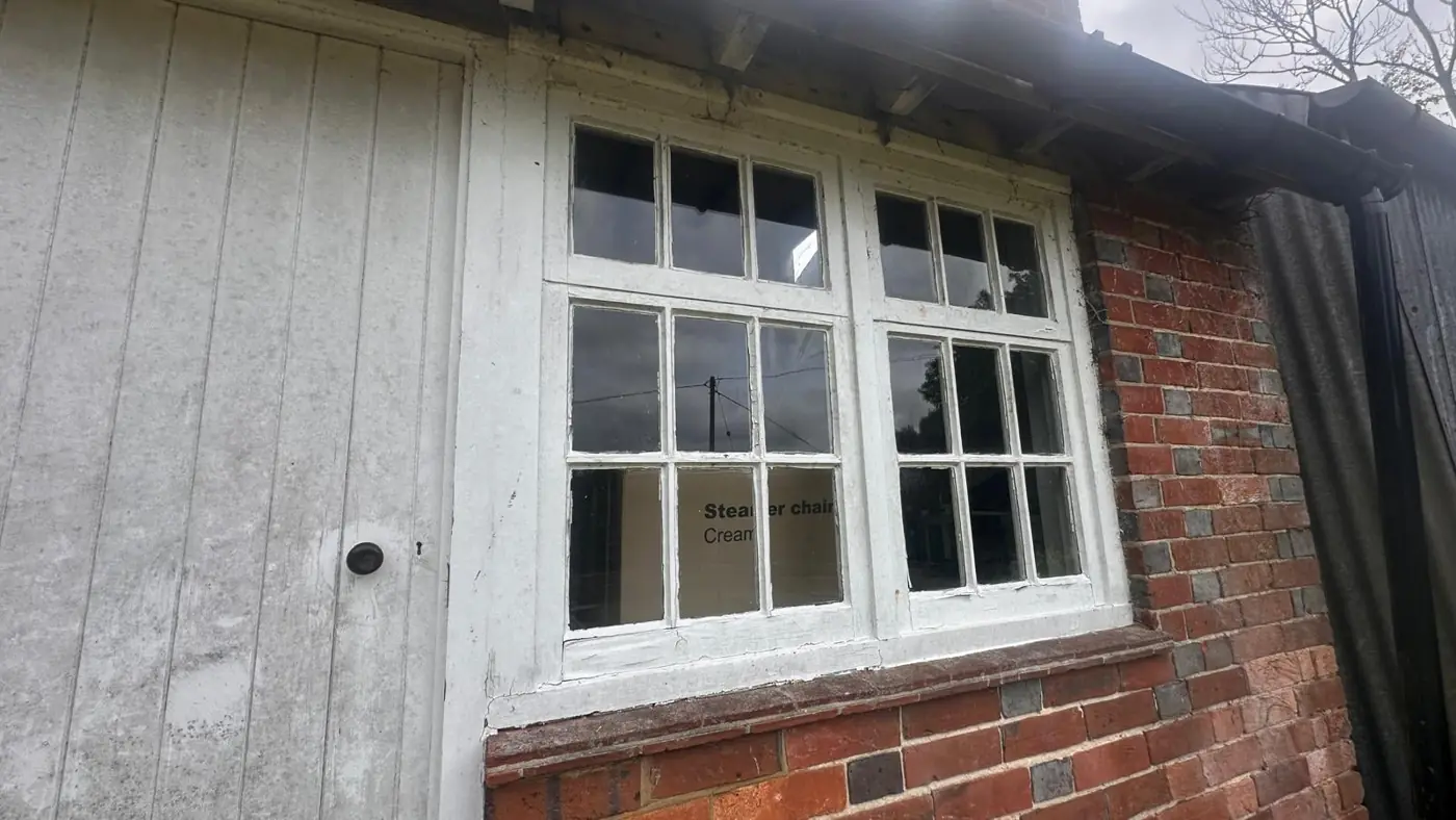
Fig. 34 — A multi-pane timber casement, painted white, set within a painted softwood frame. The small, regular pane grid is typical of early-to-mid twentieth-century workshop glazing on farm outbuildings.
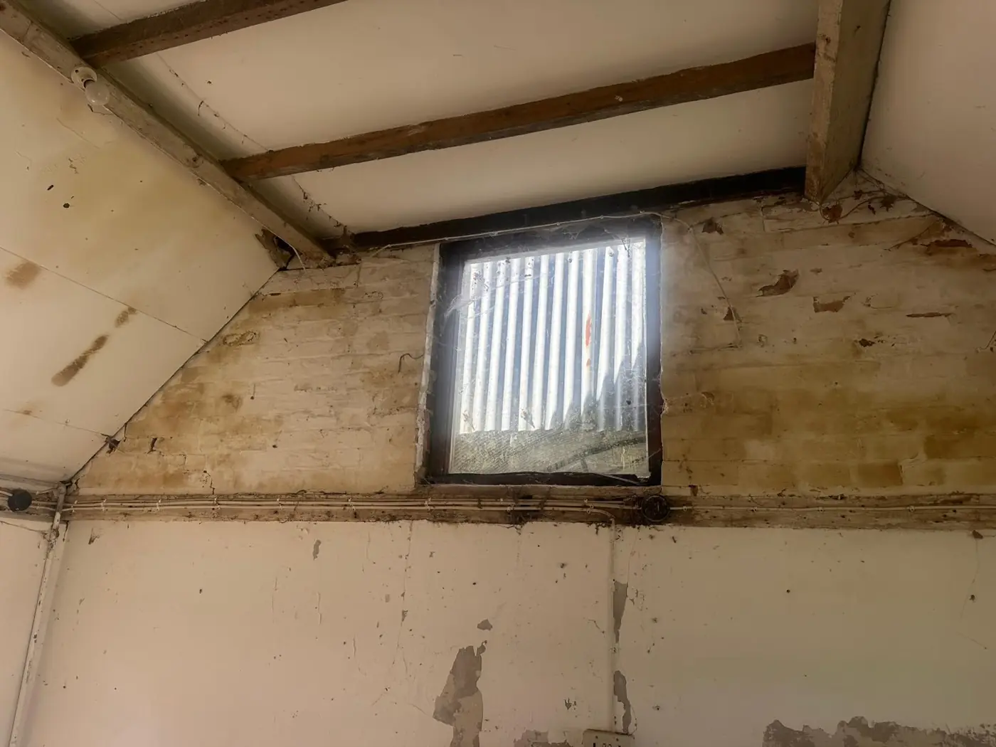
Fig. 35 — A small, near-square opening high in an internal masonry wall, with a plain flat frame consistent with ventilation or secondary lighting rather than a primary domestic window. The frame's junction with the wall suggests it may not be original to the opening, though the opening itself could be earlier.
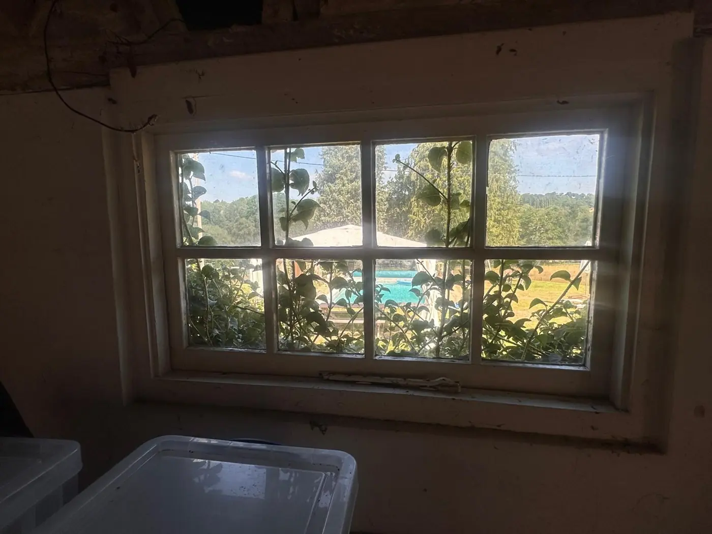
Fig. 36 — A timber-framed casement of eight panes in two rows, with a central glazing bar. The painted softwood frame and slim bars are consistent with mid-twentieth-century or earlier joinery, though heavy paint build-up makes precise dating difficult.
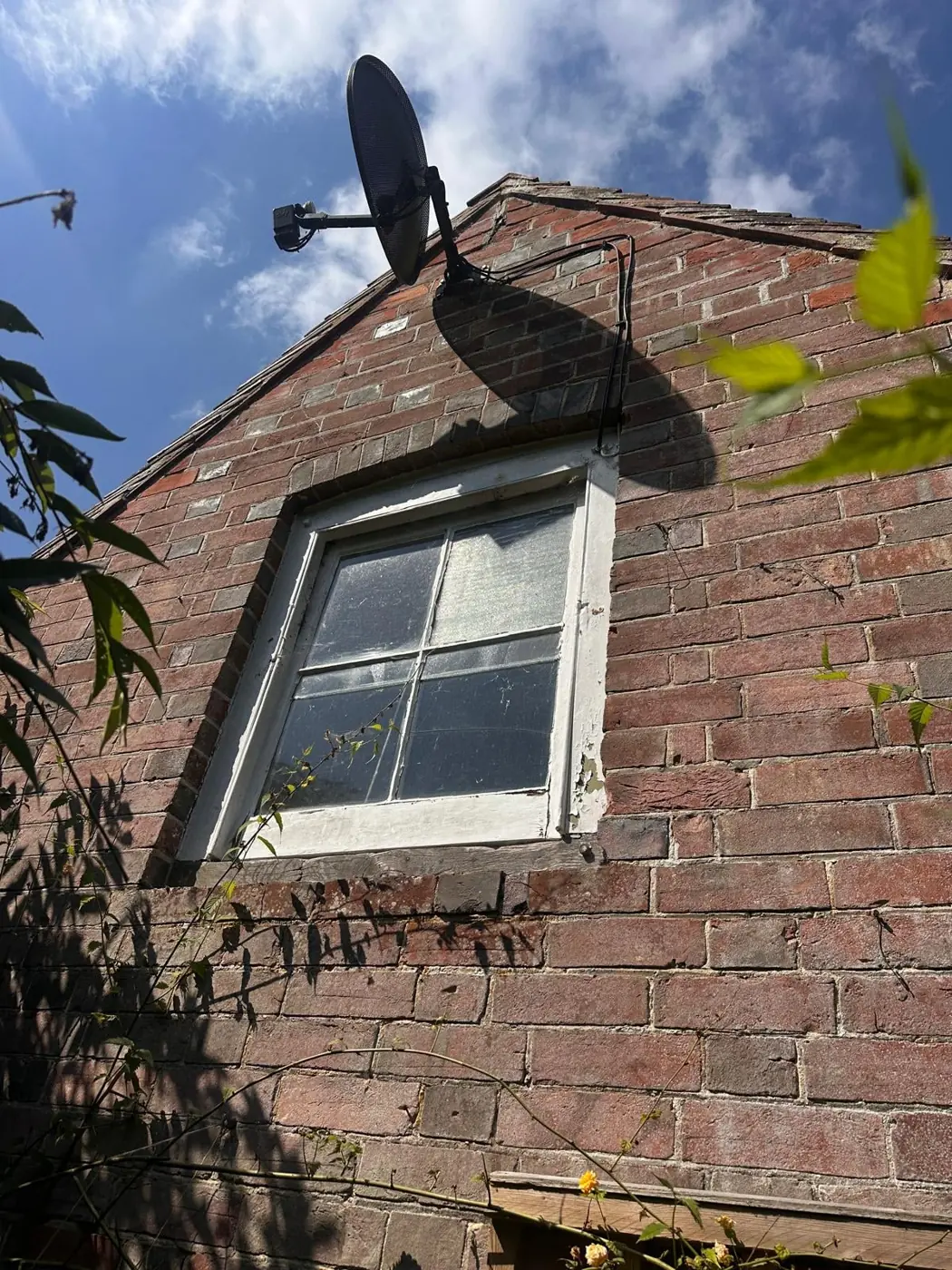
Fig. 37 —A four-pane timber casement set directly into the brick opening with no visible lintel — the brickwork itself forms the head, a modest, vernacular detail typical of farm buildings. The frame sits close to flush with the outer face, which may indicate a later re-glazing of an earlier opening.
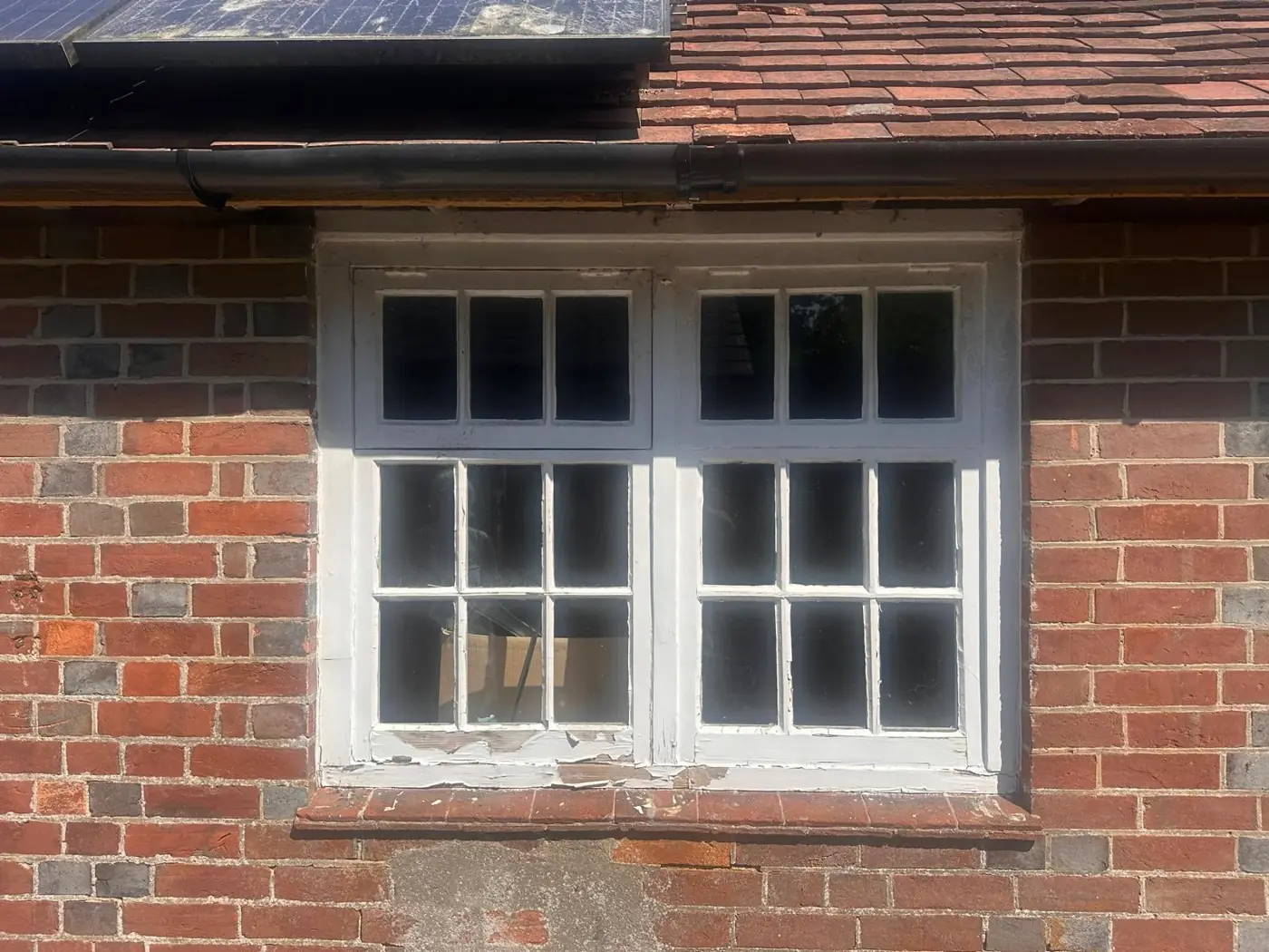
Fig. 38 — A pair of timber casements, three-over-six in the lower lights with a three-pane fixed toplight above each — a configuration consistent with late eighteenth- or early nineteenth-century joinery. Whilst the left hand side of the brick indicates an original structural opening by virtue of the queens closers, the right hand side has been adapted later indicating the opening is not wholly original. Light investigation into the construction of the window indicates a poorly matching approximation of other windows with fatter glazing bars and simpler detailing.
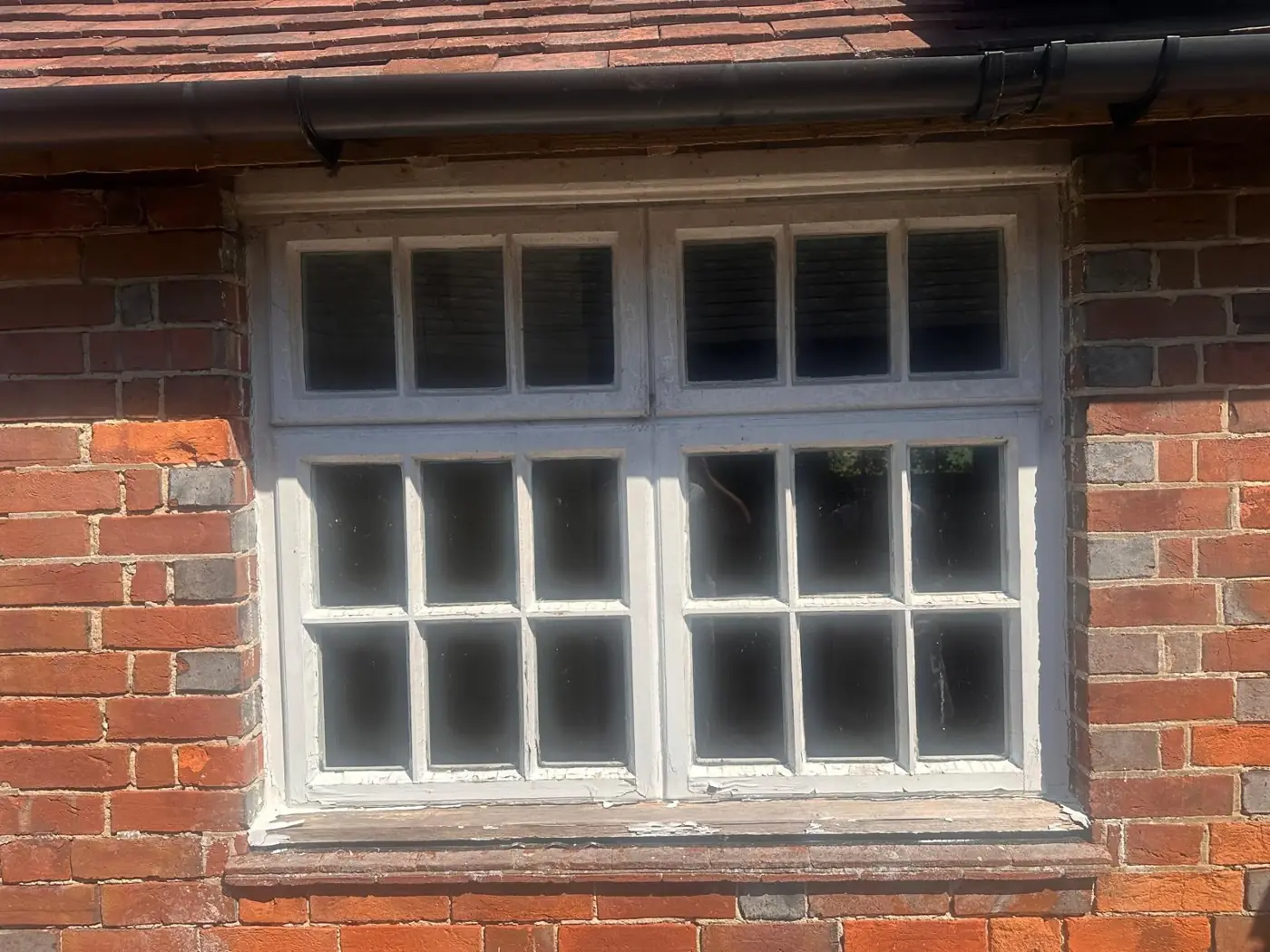
Fig. 39 — A two-light timber casement window, three-over-six with a three-pane transom above each light, set within a timber-lintelled opening with a brick sill. The small pane sizes and slender glazing bars are consistent with a late Georgian date, and this appears to be the most historically genuine window surviving in the group. Paint layers may obscure further detail.
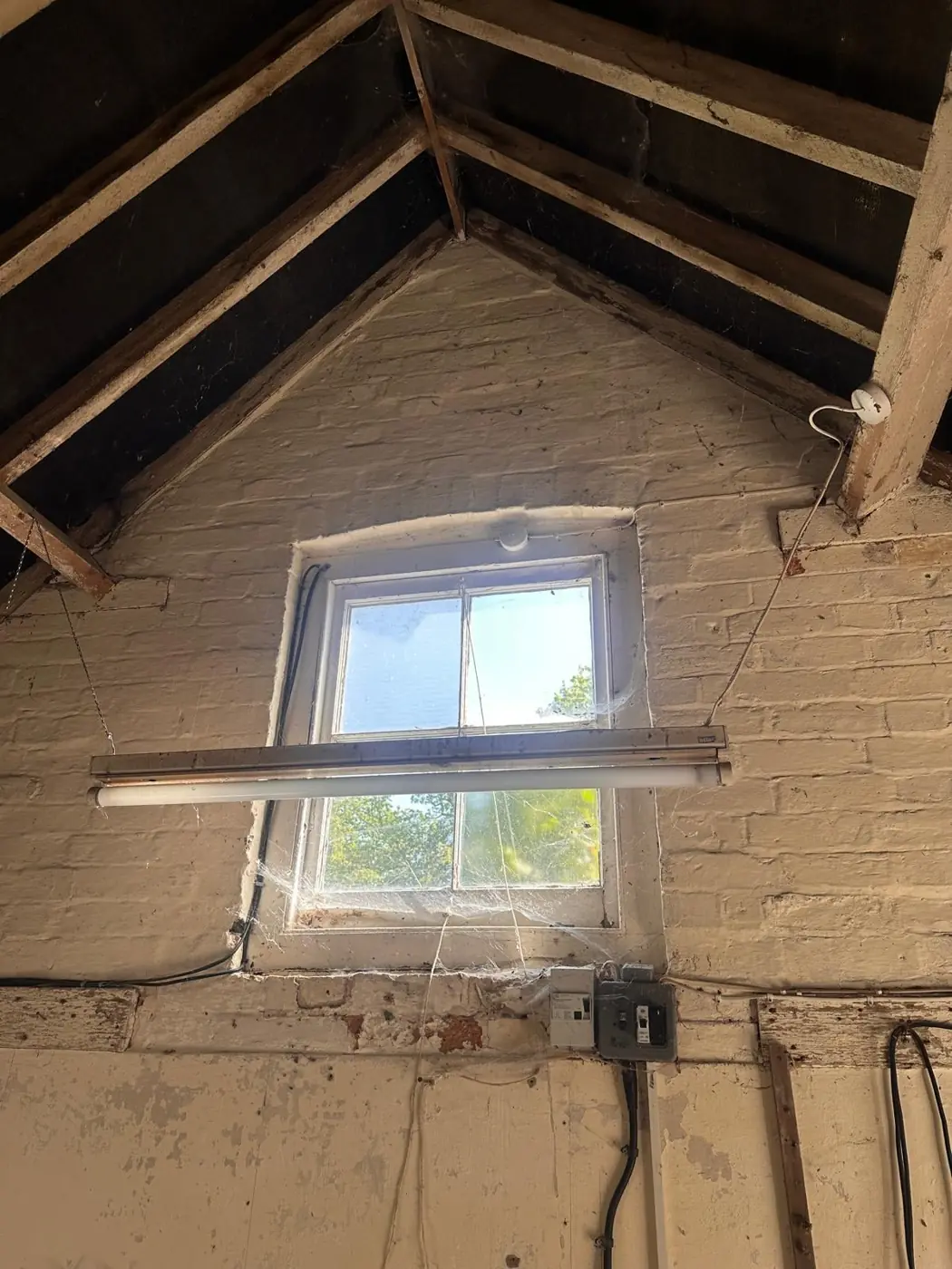
Fig. 40 — A small two-over-two casement in the gable end of an ancillary building, assembled from mismatched components — the frame, glazing bars and panes of glass appear to be of differing ages and origins. This reads as a cobbled-together twentieth-century repair rather than a coherent historic window, and is of low evidential value. The shallow brick surround beneath it may be the earlier opening.
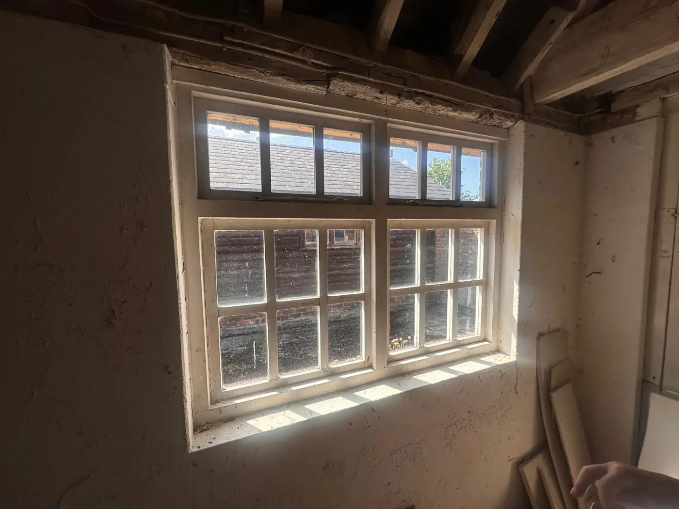
Fig. 41 — A paired casement window viewed from inside, each light of six panes with a three-pane transom above — a form consistent with an eighteenth- or early nineteenth-century opening, though its position suggests a later insertion. The regularity in the glass and clumsy, fat glazing-bar detail indicate a later window copied roughly from an earlier version.
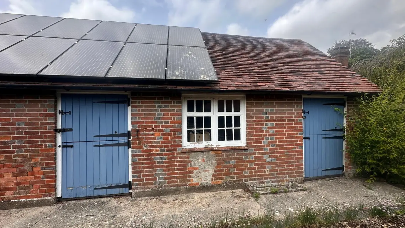
Fig. 42 — Two boarded doors on this elevation, each hung on black strap hinges with a bar latch — ironmongery typical of late nineteenth- or early twentieth-century farm joinery. The blue paint is a later finish; the white-painted thresholds appear to be later repairs.
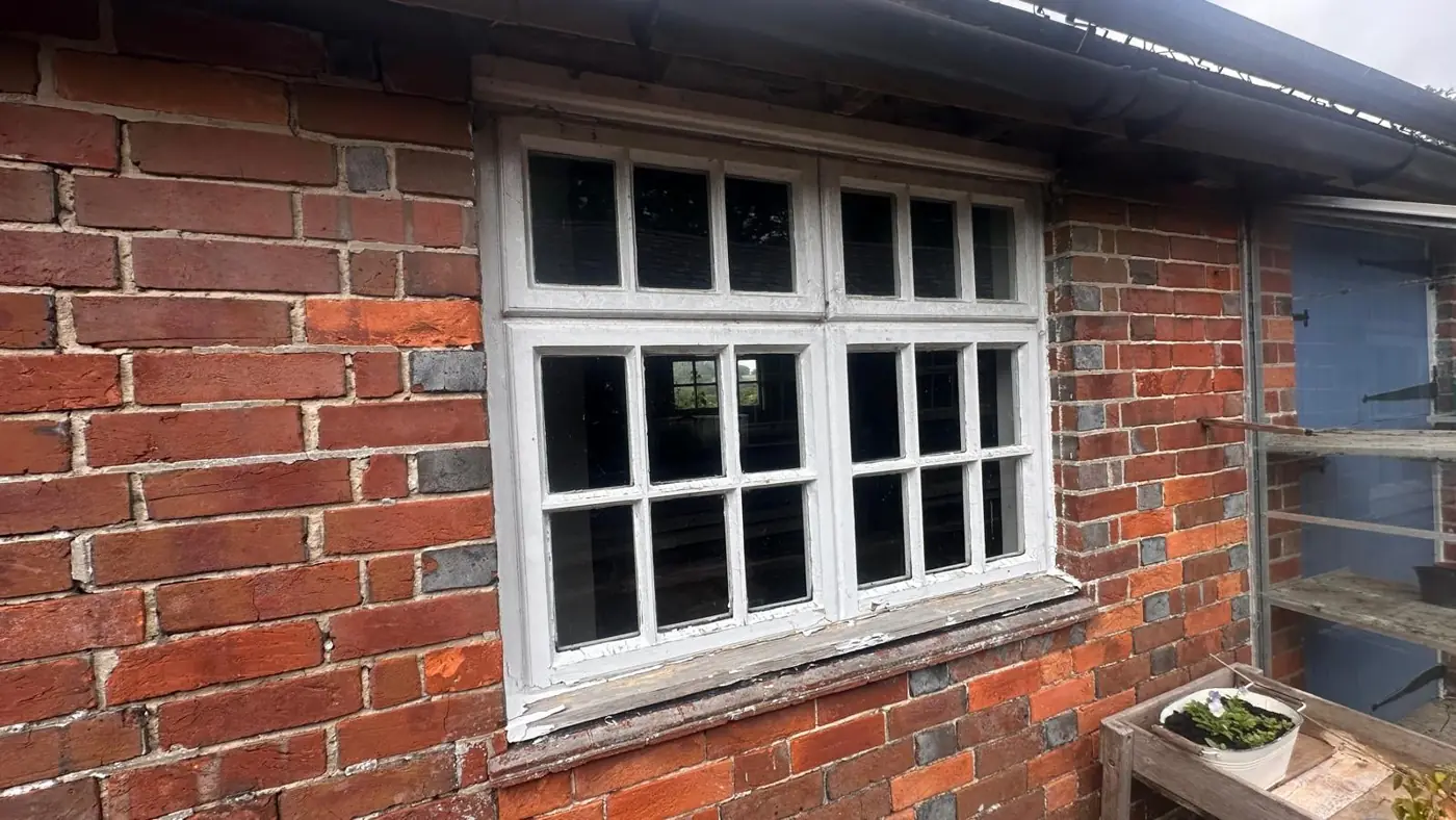
Fig. 43 — A window combining a fixed eight-pane transom above two paired two-over-two lights — a generous, utilitarian pattern typical of late nineteenth- or early twentieth-century workshop windows built to maximise daylight. Paint loss at the sill suggests long standing use, likely in its original form.
Doors — detailed study
- The doors studied range from a substantially intact nineteenth-century stable door with hand-forged strap ironmongery (Fig. 46) — the most significant example — to mid-to-late twentieth-century garage doors of recent construction (Fig. 52). Several internal ledged-and-braced doors are of probable nineteenth- or early twentieth-century origin, though later hardware and repairs make precise dating uncertain in most cases.
This plan shows where each close-up photograph in this study was taken and the direction the camera was pointing, with north marked at the top. The photographs that follow are presented in that same sequence, starting with Fig. 45 below.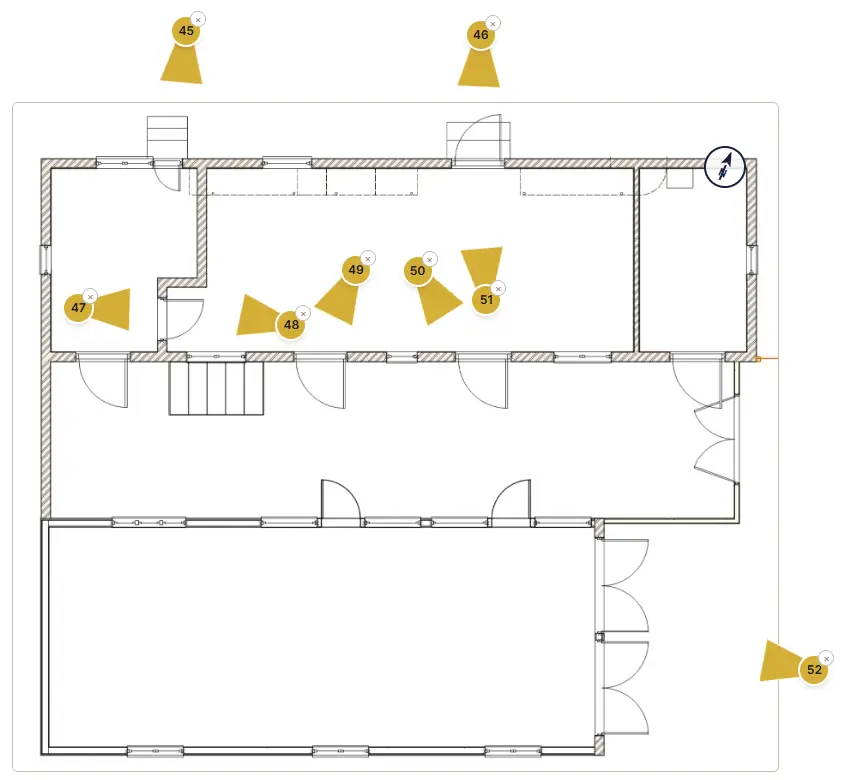
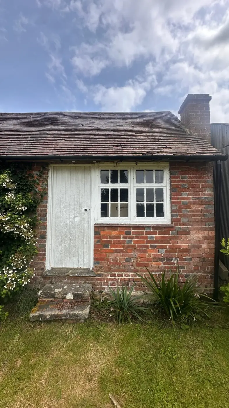
Fig. 45 — A plain flush timber door set beside a six-pane timber casement in the brick elevation. The door's modern timber lining and the concrete threshold beneath it indicate this is a later insertion rather than a historic opening, of limited evidential interest. The adjoining casement is of the same type recorded elsewhere in this study.
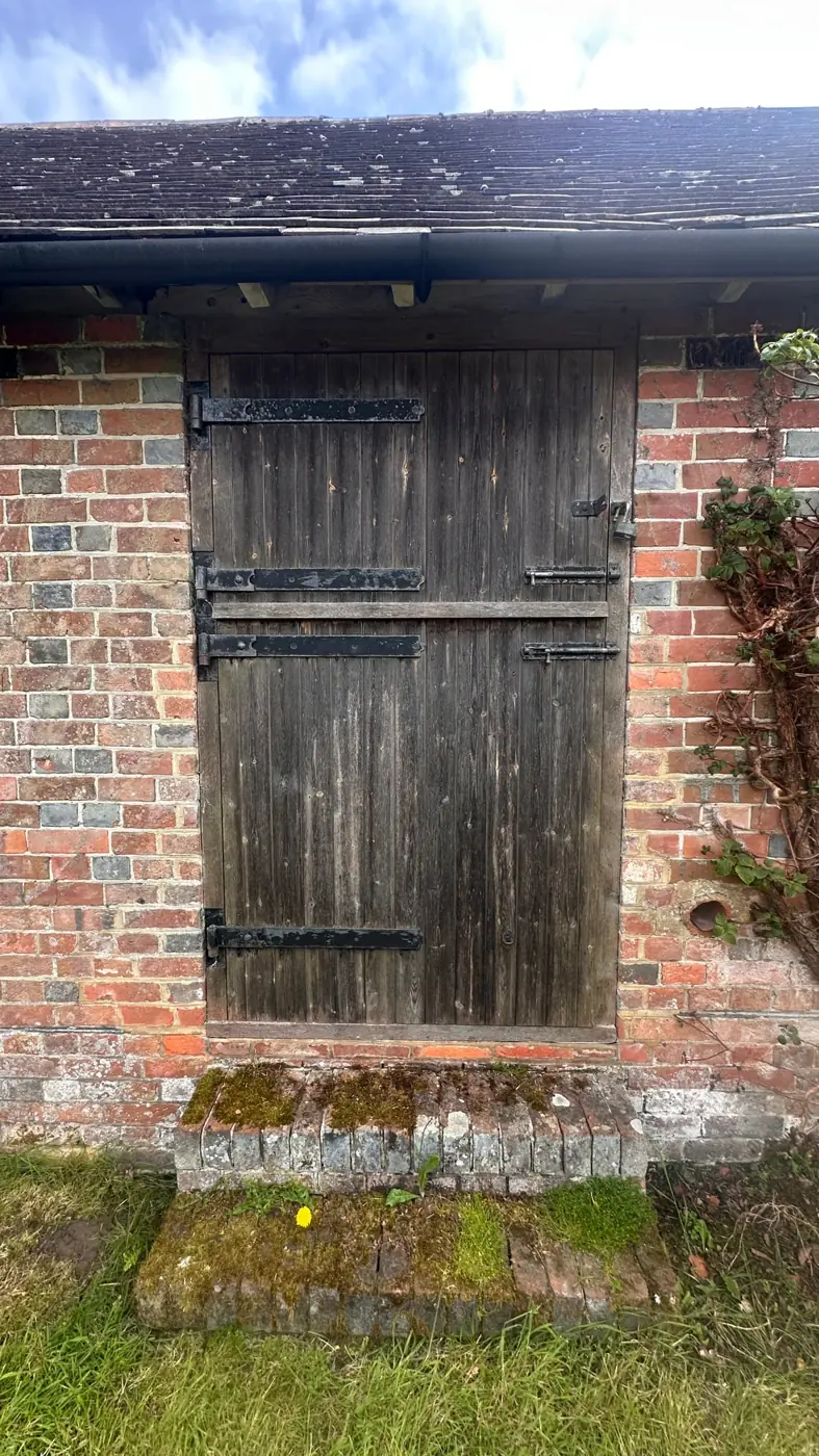
Fig. 46 — A vertically-boarded stable door in two independently-hung leaves, secured with substantial black strap hinges — three to the lower leaf, two to the upper. The form and ironmongery are consistent with nineteenth-century agricultural use, and the door appears largely unaltered.
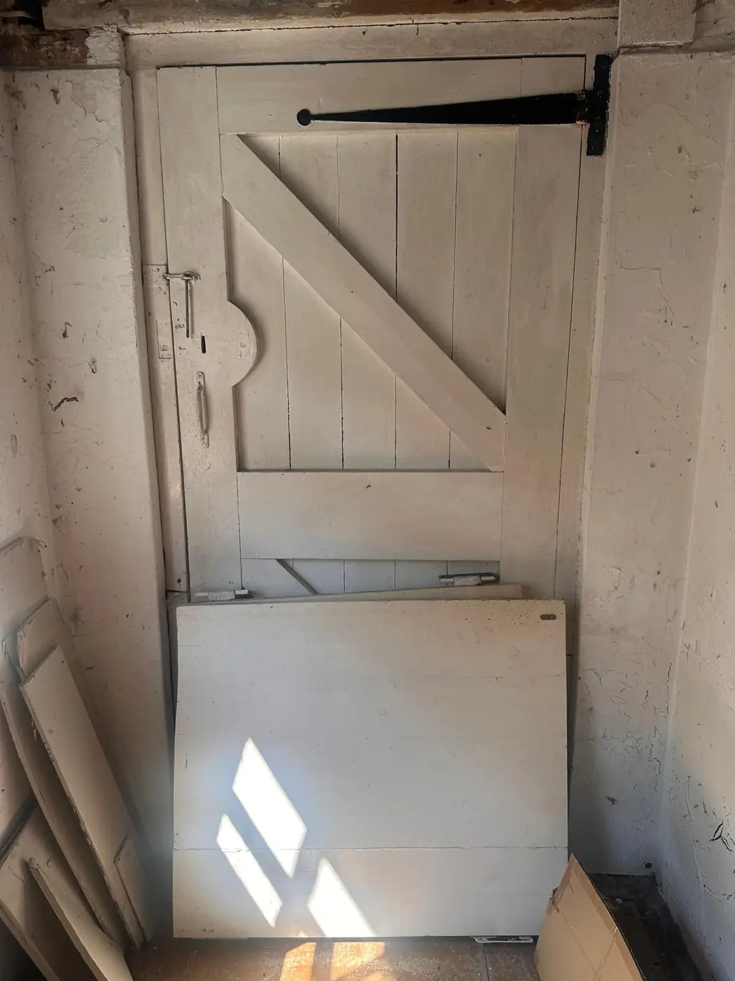
Fig. 47 — A ledged-and-braced softwood door with one surviving hand-forged strap hinge, consistent with nineteenth- or early twentieth-century farm joinery. A later scroll escutcheon and lever latch show at least one round of hardware replacement. The lower leaf, detached and resting against the opening, suggests this was once a divided stable door..
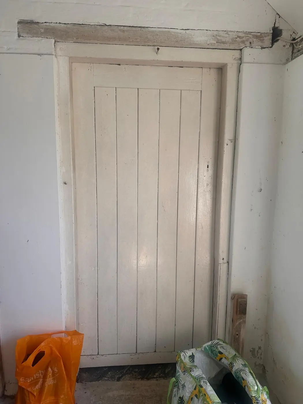
Fig. 48 — A boarded timber door of close-set vertical boards in a plain painted frame, its form consistent with pre-twentieth-century construction, though heavy paint obscures further detail. A lock-plate mortice suggests a former rim or mortice lock. The substantial timber lintel above may indicate the opening itself is of some age.
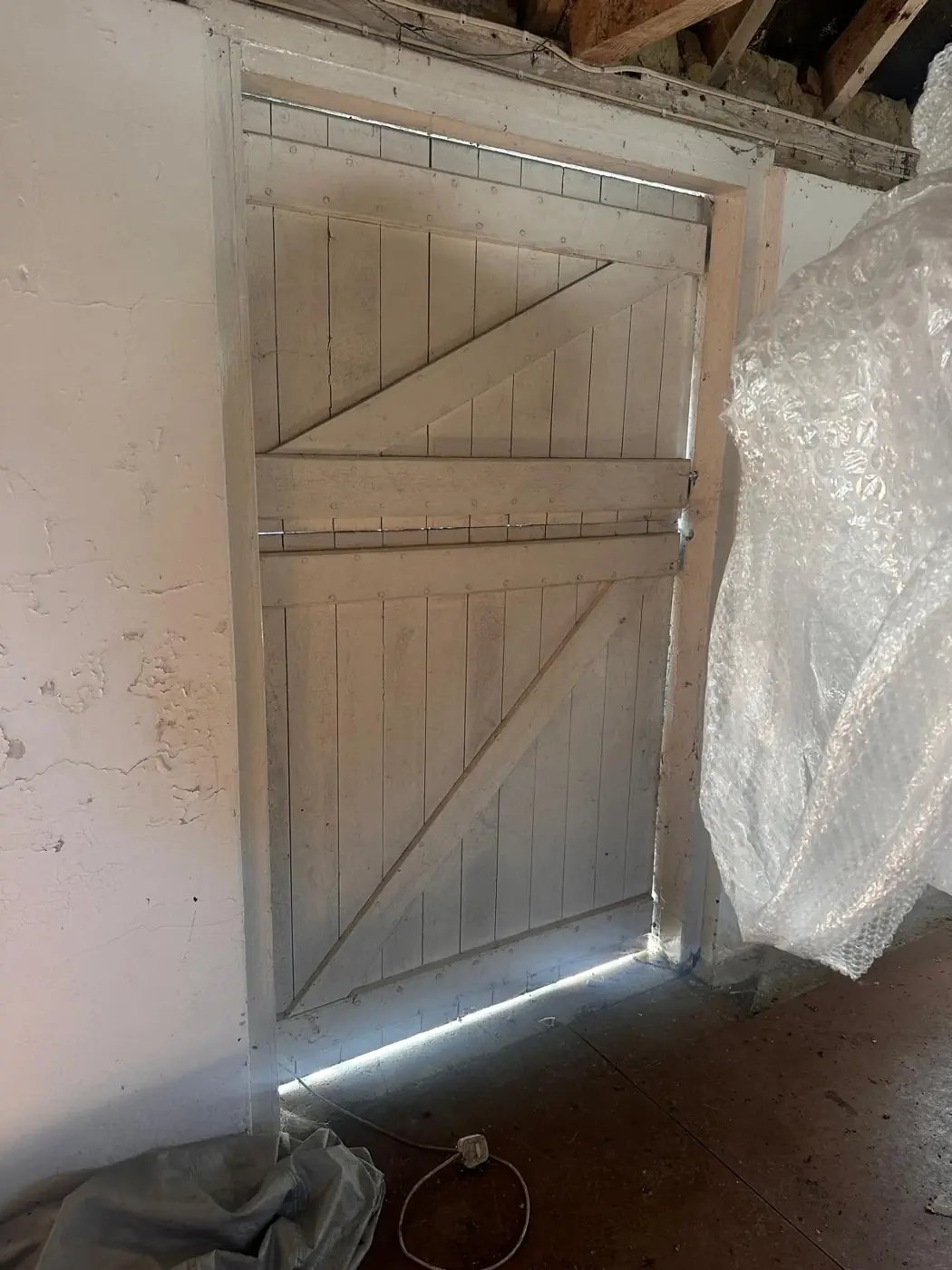
Fig. 49 — A ledged-and-braced door with paired diagonal braces set in opposing directions on the upper and lower leaves — a form associated with stable or agricultural use. The chamfered frame detail suggests a nineteenth- or early twentieth-century date; a later metal bolt on the mid-rail shows subsequent adaptation.
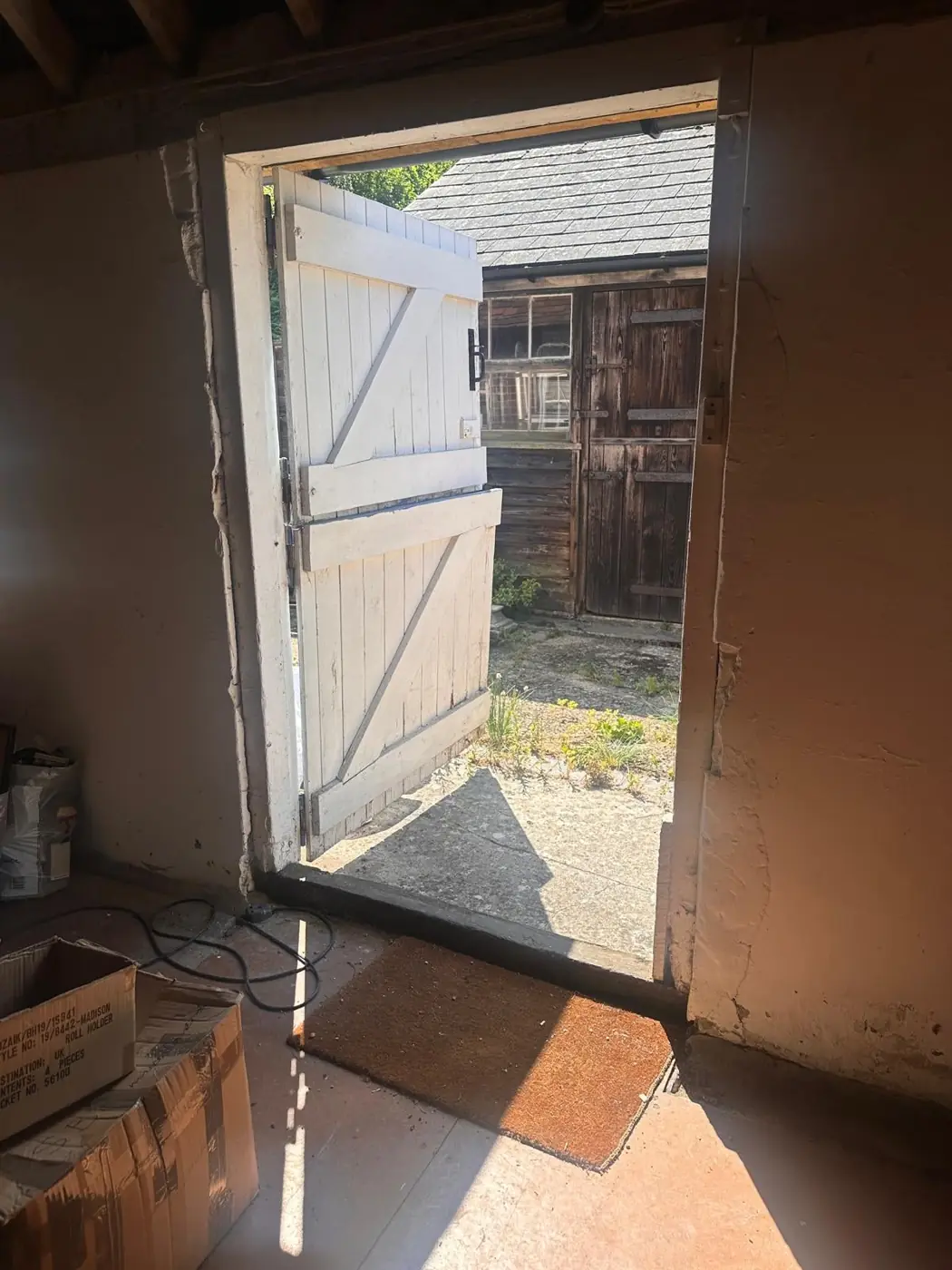
Fig. 50 — A two-leaf ledged-and-braced stable door in vertical softwood boarding, consistent with nineteenth- or early twentieth-century agricultural use. The white paint is worn and not recent; the black metal latch reads as a later replacement fitting.
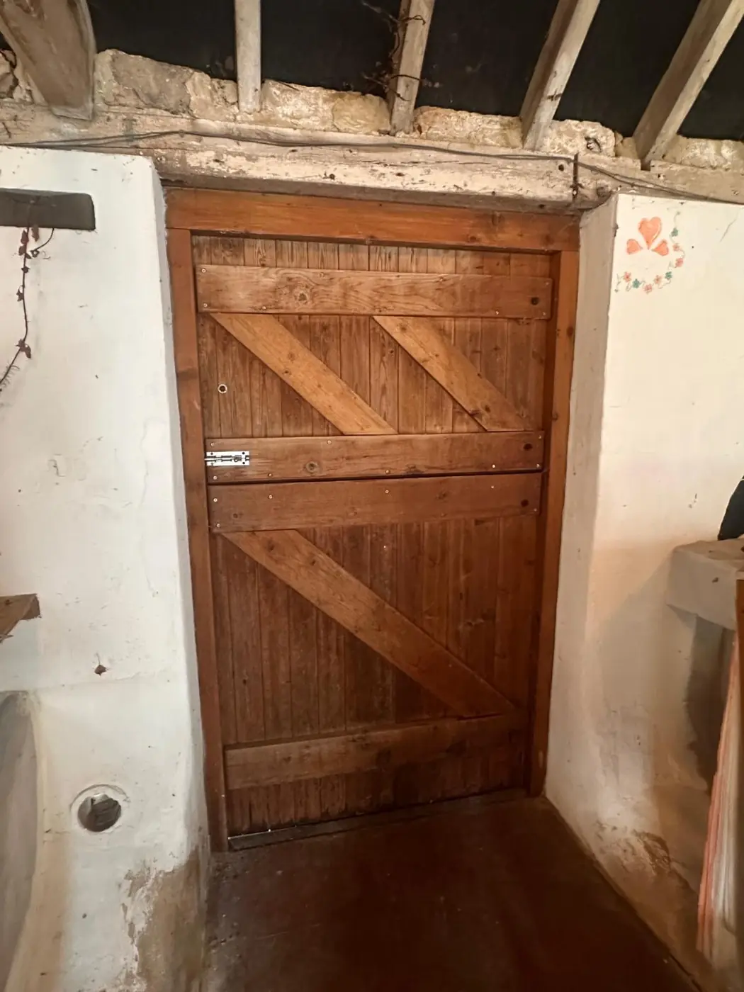
Fig. 51 — A boarded door in a softwood frame against a rubble masonry reveal, its Z-pattern bracing across both leaves suggesting a divided stable or half-door arrangement. The clean, machine-precise boards point to a twentieth-century or later replacement within what may be an earlier opening.
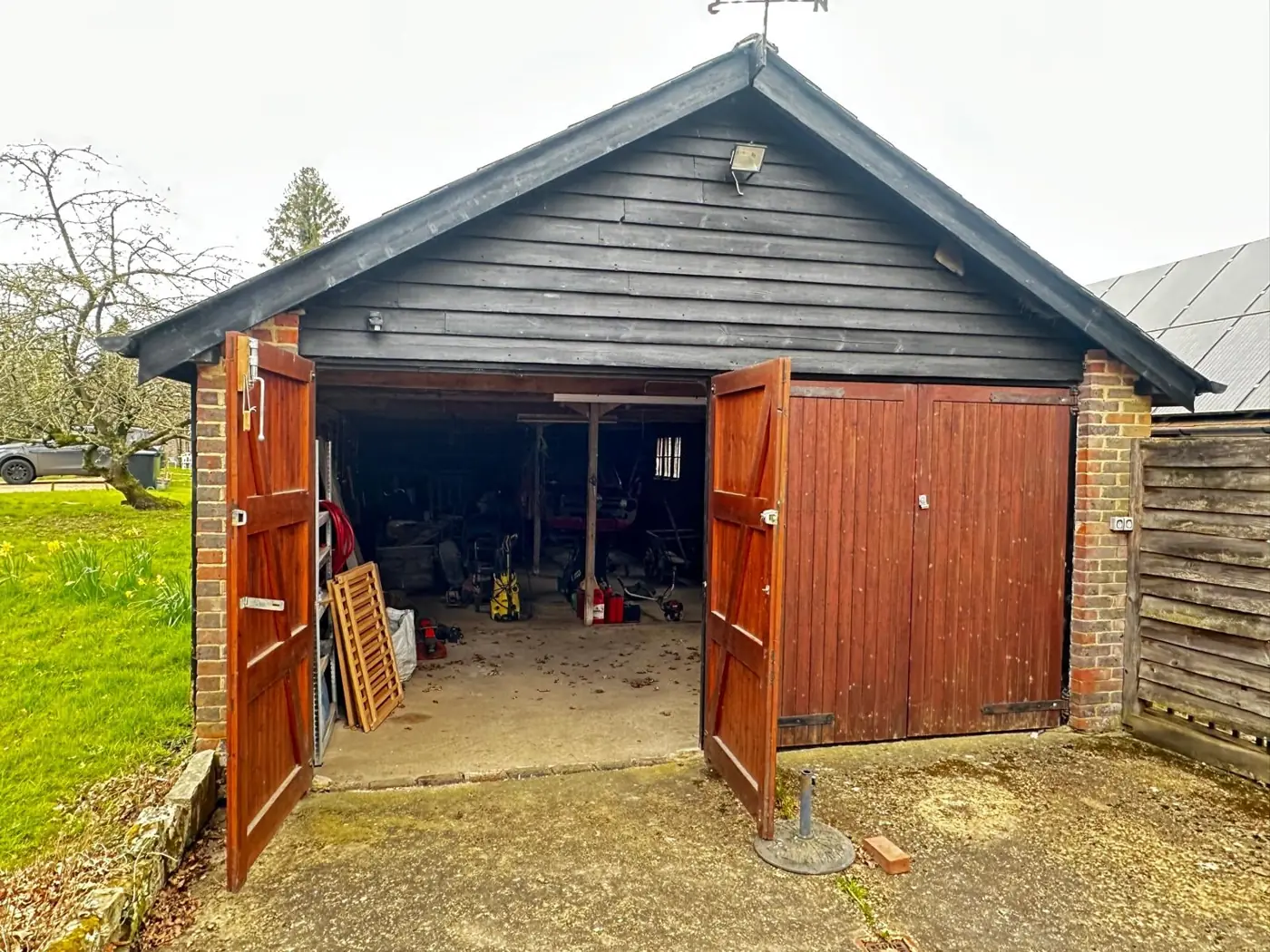
Fig. 52 — The double-leaf boarded garage doors, hung on strap hinges and finished in red-brown stain, are consistent with mid-to-late twentieth-century construction. A matching pair to the right suggests the garage was built as a two-bay structure from the outset.
 2.7 Building Age & Significance Plan
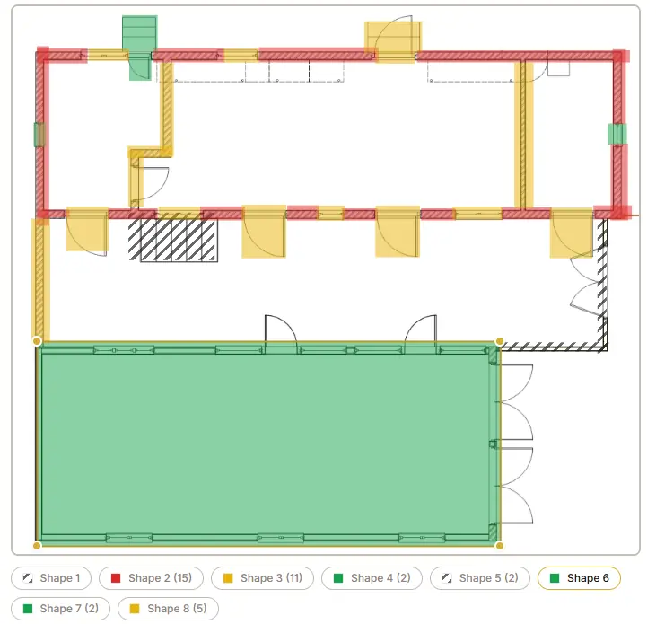
Fig. 32 — Floor plan — Ground Floor Plan — cropped-base-plan.png
Photograph pin key: the pin numbers on this plan are the figure numbers of the pinned photographs (Figs. 15–31), whose captions appear with the photographs.
Significance grading key: the six-marker scale the markings are drawn from is set out at §1.7 Approach and methodology.
- Numbered photograph pins and significance grading markers are drawn onto the embedded plan figures, each with a key beneath it. The pin numbers are the document-wide figure numbers of the pinned photographs. The schedule below carries the marker categories and the reasoning recorded against each.
Significance grading key (categories used on this plan)
- The categories used on this plan — Red, Yellow, Green, Hatched and Cloud — are defined in the six-marker grading key at §1.7.
Feature significance assessments
Red — High/Considerable significance
- The 19th-century Flemish bond brickwork laid in lime mortar is the most significant fabric element of the curtilage outbuildings. Dating to the Victorian period, it is uncommon regionally and carries medium architectural and historic interest, with local associative value. The brick is understood to be handmade material reused from a demolished earlier range on the holding, so the individual bricks do not themselves date the walling; see §2.8. The fabric has been altered but remains legible, and its evidential value lies in recording mid-to-late 19th-century construction practice and materials. Its medium aesthetic quality, and the care evident in the original execution of the bonding pattern and lime mortar, contribute to the character of the farmstead group. Within the context of these unlisted ancillary structures the brickwork is of high significance; relative to the principal listed farmhouse, and given the cumulative heritage value of the site, its overall significance is assessed as considerable.
- Shape 2 — C19 Flemish Bond brickwork with lime mortar (15 areas marked)
Criterion | Assessment |
|---|---|
Age / period | Victorian (1837–1901) |
Rarity (supporting criteria) | Medium (uncommon regionally) |
Architectural and artistic interest (supporting criteria) | Medium |
Historic interest (supporting criteria) | Medium (local association) |
Archaeological interest (supporting criteria) | Low |
Group value (supporting criteria) | Low |
Intactness | Altered but legible |
Aesthetic value | Medium |
Communal value | Low/None |
Evidential value | Medium |
Overall significance grade | Considerable/High (Red) — Relative to the other parts of these outbuildings, the significance of this brickwork is high but compared to the main building and the fact these structures are not listed it could be seen as medium overall. |
Yellow — Some significance (Medium)
- The windows and doors across the farmstead, and the 20th-century brickwork, are of medium significance and document the buildings' evolution and current character. The painted and stained timber windows and doors are attributed to the Edwardian and Interwar period, though their styles and detailing indicate multiple alterations and amendments over time, and several are no longer in their original positions. Individually they are of low architectural and artistic interest and common in agrarian contexts; collectively they convey the property's historical phases, with limited group value given the variety across the site. They carry medium aesthetic value and local historic interest. The post-war and modern brickwork of 1945–2000 comprises later additions: the external walls joining the modern garage to the storage barn, and internal partitioning within the barn. This fabric is substantially unaltered since construction. It is low in historic and archaeological interest but has medium aesthetic value in defining the courtyard enclosure and marking the original outline of the building cluster. The external boundary wall is of greater significance than the internal partitioning in this respect, because it establishes the historic spatial relationship and ownership definition of the site.
- Shape 3 — All painted timber or stained windows and doors (11 areas marked)
Criterion | Assessment |
|---|---|
Age / period | Edwardian/Interwar (1901–1939) — Unable to verify without paint scrape analysis but styles and detail imply several alterations and amendments over time. |
Rarity (supporting criteria) | Low (common, well represented) |
Architectural and artistic interest (supporting criteria) | Low |
Historic interest (supporting criteria) | Medium (local association) — Typical window agrarian styles but not particularly well made. |
Archaeological interest (supporting criteria) | Negligible |
Group value (supporting criteria) | Medium — Read together they give an indication of a style but there is such a variety that this holds little value but should be noted. |
Intactness | Altered but legible — Several windows are not in original positions. |
Aesthetic value | Medium |
Communal value | Low/None |
Evidential value | Low |
Overall significance grade | Some (Yellow) |
- Shape 8 — 20th Century Brickwork with cementitious mortar (5 areas marked)
Criterion | Assessment |
|---|---|
Age / period | Post-war/Modern (1945–2000) — Later additions after the original external walls were built; other adjoining outbuildings were removed and both the external wall joining the modern garage to the brick storage barn and the internal walls inside the storage barn were built. |
Rarity (supporting criteria) | Low (common, well represented) |
Architectural and artistic interest (supporting criteria) | Low |
Historic interest (supporting criteria) | Low |
Archaeological interest (supporting criteria) | Negligible |
Group value (supporting criteria) | Low |
Intactness | Substantially unaltered — Likely to be intact from when they were first built in the 20th century. |
Aesthetic value | Medium — The external boundary wall is defining the ownership and appropriately encloses the courtyard space and defines the original wall line. |
Communal value | Low/None |
Evidential value | Low |
Overall significance grade | Some (Yellow) — Simply by virtue of the external wall defining the original outline of the building cluster. The internal walls are of lesser significance. |
Green — Neutral significance
- The site includes several post-war modern elements of neutral significance. Concrete external steps and an unusually sized door (Shape 4) are common features of the period 1945–2000 with low architectural and historic interest. A timber-clad modern garage (Shape 6) forms a substantial element of the current built form and dates to the same post-war period. Modern adaptations to windows (Shape 7) are later alterations in line with twentieth-century domestic practice. Collectively, these features do not materially contribute to the heritage value of the farmhouse and its curtilage.
- Shape 4 — Concrete external steps and unusual sized door. (2 areas marked)
Criterion | Assessment |
|---|---|
Age / period | Post-war/Modern (1945–2000) |
Rarity (supporting criteria) | Low (common, well represented) |
Architectural and artistic interest (supporting criteria) | Low |
Historic interest (supporting criteria) | Low |
Overall significance grade | Neutral (Green) |
- Shape 6 — Timber clad modern Garage construction (1 area marked)
Criterion | Assessment |
|---|---|
Age / period | Post-war/Modern (1945–2000) |
Overall significance grade | Neutral (Green) |
- Shape 7 — Modern adaptions on windows (2 areas marked)
Criterion | Assessment |
|---|---|
Age / period | Post-war/Modern (1945–2000) |
Overall significance grade | Neutral (Green) |
Hatched — Negative/Detracting
- Two elements within the curtilage are graded negative or detracting to the significance of the heritage asset. An external greenhouse (Shape 1) of 21st-century date adds no character or value to the farmhouse and its associated buildings; it is fragmentary in condition and contributes negatively to group value, though it causes no material harm. External timber fencing in poor condition (Shape 5), also of 21st-century origin, likewise detracts from the setting. Neither element possesses architectural, historic, archaeological, aesthetic, communal or evidential value. Both are later domestic additions that lack integration with the historic character of the farmhouse and its curtilage.
- Shape 1 — External Greenhouse (1 area marked)
Criterion | Assessment |
|---|---|
Age / period | 21st century |
Rarity (supporting criteria) | Low (common, well represented) |
Architectural and artistic interest (supporting criteria) | Negative (later work harms coherence) |
Historic interest (supporting criteria) | None identified |
Archaeological interest (supporting criteria) | Negligible |
Group value (supporting criteria) | Negative |
Intactness | Fragmentary |
Aesthetic value | Low |
Communal value | Low/None |
Evidential value | Low |
Overall significance grade | Negative/Detracting (Hatching) — The greenhouse is causing no real harm but adds nothing to the character of the buildings other than helping define them as domestic. |
- Shape 5 — External timber fencing in poor condition (2 areas marked)
Criterion | Assessment |
|---|---|
Age / period | 21st century |
Overall significance grade | Negative/Detracting (Hatching) |
2.8 Assessment of significance
- The significance gradings recorded by the heritage professional on the Building Age & Significance Plan (§2.7) are restated here in summary. This summary re-presents those gradings as recorded; it does not itself assign or alter any grading.
- Considerable/High (Red): C19 Flemish bond brickwork with lime mortar.
- Negative/Detracting (Hatching): External greenhouse; external timber fencing in poor condition.
- The elements graded Some (Yellow) and Neutral (Green) are scheduled, with their reasoning, at §2.7 and are not restated here. Window ironmongery is marked Cloud and remains subject to further investigation before a settled grading can be assigned.
- The significance of the asset is carried principally by its earlier walling fabric; the later material contributes at a lower level, and a small number of recent external additions detract from its setting. The gradings at §2.7 establish a clear hierarchy: the evidential and historic interest of the asset is concentrated in the principal brick walling, and it is against that core that the contribution of everything else falls to be understood. The neutral and detracting elements are all later and readily distinguishable from the fabric of interest, so the pattern of significance across the site is legible in its broad outline even where individual questions of dating remain open.
- The dating of the principal walling requires careful statement. The Flemish bond and the lime mortar are consistent with a nineteenth-century campaign, and the professional's grading proceeds on that basis. Complicating this, the brick itself is understood to be handmade material reused from a demolished earlier range on the same farm, so the character of the individual bricks predates the walls they now form. The brick therefore cannot serve as dating evidence for the walling in either direction: an early appearance to the brick does not indicate an early wall here, and the campaign date rests on the bonding pattern and mortar rather than the units themselves. On the evidence currently available, a nineteenth-century build in salvaged earlier brick would appear to be the most coherent reading, but this remains a fabric-based judgement; documentary sources or map regression bearing on the demolished range and its replacement would carry greater weight than a fabric read alone, and if such sources exist they are the place to test this conclusion. The reuse itself adds a strand of historic interest of its own, physically embedding the memory of an earlier building on the holding within the surviving one.
- The historic interest of the storage barn is supported by surviving fabric evidence of its working use. The in-situ trough and associated pipework (Figs 28–29) are consistent with former dairy use, and this reading is corroborated by fabric evidence rather than documentary or owner testimony. No evidence has been identified for a cart-store function, and this Statement makes no claim in that respect.
- The later fabric of some significance — the painted and stained joinery and the twentieth-century brickwork — records the continuing adaptation of the building through its working life and contributes to that narrative at a secondary level.
- Conclusion. The significance of the storage barn and garage lies chiefly in the evidential value of the principal walling — lime-bonded Flemish bond brickwork, built in the nineteenth century using earlier handmade brick reused from a demolished range on the same holding — and in the historic interest of a farm building whose long working use remains legible in its surviving form, fabric and fittings. This significance is concentrated in that earlier fabric; the later material and recent additions contribute at a secondary level or, in the case of the greenhouse and the fencing, detract from it.
- Two matters remain open and are not resolved by this Statement. First, the dating of the principal walling set out at §2.8.6 is coherent on the fabric evidence available but would be more firmly established by documentary or cartographic sources bearing on the demolished range; if such sources exist, they should be sought before this dating is treated as settled. Second, the window ironmongery is marked Cloud pending further investigation, and no grading is drawn on it here.